
Making Sense of ENSO and US Impacts
Austin Pearson – Extension Educator
Purdue Extension – Tipton County
08 September 2021
Chances are you have heard the term “ENSO” thrown about by TV meteorologists a few times, and you might have wondered what in the world they were talking about. In an acronym-heavy industry, you can quickly get lost when the alphabet soup is served. ENSO is not the name of your favorite Sci-Fi movie character, but is the acronym for a naturally occurring phenomenon located along the equator in the Pacific Ocean called the El Niño-Southern Oscillation. Scientists pay close attention to sea surface temperatures (SSTs) in this region as the varying temperatures impact the positioning of jet streams in the winter and hurricane development in the summer. There are three ENSO phases: ENSO neutral, El Niño, and La Niña. ENSO neutral refers to normal SSTs (75-80 degrees Fahrenheit) and is generally associated with fairly normal winter weather patterns across the US. Much of the Midwest is dominated by cold temperatures, while the southern US is warm and wet. Hurricane development is normal during this phase.
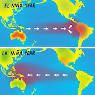
El Niño conditions are present when SSTs are 0.5-degree Fahrenheit warmer than normal and contributes to warmer, drier conditions across the northern US, with wet weather in the southern US during the winter. Hurricane development in the Atlantic tends to be lessened, but the development in the Pacific is amplified.
You have probably guessed it by now, but La Niña conditions are present when SSTs are 0.5-degree Fahrenheit cooler than normal. These patterns are associated with cold, wet winters across much of the northern US and warmer, drier conditions in the southern US. Hurricane development in the Atlantic is amplified. For more detailed information on ENSO conditions, refer to the National Oceanic Atmospheric Administration’s Climate.gov website.
SSTs are monitored weekly by the national Climate Prediction Center. Status information is located in the Weekly ENSO Evolution, Status, and Prediction Presentation sections that are publicly available on the Climate Prediction Center website. This website is updated every Monday and includes a summary of ENSO Alert System Status, conditions present, and an ENSO seasonal forecast. Currently, ENSO-neutral conditions are present and are expected to continue through the remainder of summer. There is 70% confidence in development of La Niña conditions through the upcoming winter.
If you are curious about Midwestern impacts, the collaborative Useful to Usable program developed a tool called the Climate Patterns Viewer. The product analyzes historical weather data during the three ENSO phases and compares them to the 1981-2010 climate normals. Monthly trends in precipitation and temperature can be accessed through the map feature on the tool. This tool is not to be used as a forecast, but more as an assessment of general trends in ENSO induced patterns in the Midwest.
Next time you hear your local TV meteorologist refer to ENSO, you are now a little bit more familiar with the term. For questions, you may contact Austin at the Purdue Extension – Tipton County office via pearsona@purdue.edu or 765-675-1177, or the Indiana State Climate Office at 765-494-8060.