
Wildfire Research and Solutions
Advancing wildfire Prediction, Prevention and Management
In 2024, wildfires burned nearly 9 million acres across the United States, outpacing both the five-year and 10-year averages.* The impacts can be far-reaching and costly – for individuals, businesses, communities and ecosystems.
Purdue’s Institute for Digital Forestry is working to enhance wildfire prediction, monitoring and management through our unique multidisciplinary approach to research and development. The Institute brings together experts in forestry, engineering, computer and information sciences, and social sciences to develop solutions that are both innovative and practical.
In the lab and in the field, we’re focused on:
- Real-time Monitoring
- Fire Modeling
- Innovative Technology and Tools
Real-time monitoring
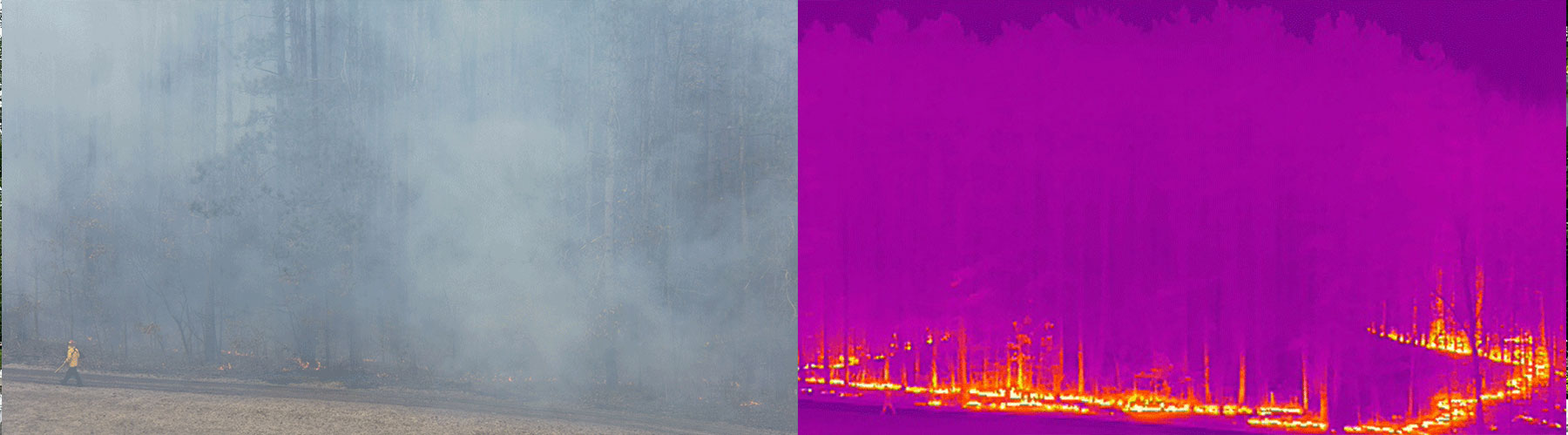
Effective wildfire prediction and risk mitigation require accurate, real-time environmental data. Using real-time ground sensing, drones with LiDAR and thermal sensors and a satellite-based platform, we gather data on critical variables like soil moisture and above-ground biomass at a global scale.
The Institute for Digital Forestry uses cutting-edge remote-sensing technology to provide high resolution canopy-level and ground-level insight that enables accurate and scalable fire risk predictions:
- VPD Sensors: Measure vapor pressure deficit to analyze how moisture moves between the soil, vegetation, and atmosphere.
- LiDAR Remote Sensing: Provides precise, high-resolution biomass mapping to detect vegetation density and potential fuel loads.
- Hyperspectral Imaging Remote Sensing: Captures detailed spectral data to identify stressed vegetation, an early indicator of fire-prone conditions.
- Active and Passive Remote Sensing Techniques: Combine multiple sensing methods for a comprehensive assessment of environmental conditions affecting wildfire spread.
fire modeling
Institute for Digital Forestry researchers assess fire risk and model behavior by:- Combining satellite, drone and ground data to detect risk factors such as biomass density.
- Using AI-powered analysis to predict fire behavior.
- Implementing prescribed burns to reduce excess fuels.
innovative technology and tools
Powerful technologies help expand the scope and improve the efficiency and accuracy of our wildfire research and development efforts. From backpack technology to drones and planes to satellite, we can capture a ground-to-sky perspective of forested lands that improves the ability to assess and manage fire risk across varied landscapes.
martell tower
Martell Tower is a portable and remote sensing platform located at Purdue’s Martell Forest, a 477-acre research property. The tower will be equipped with advanced sensors that collect continuous, high-accuracy environmental data.
Martell Tower plays a pivotal role in refining wildfire risk models by leveraging multiple remote sensing applications to:
- Monitor Soil Moisture Levels: Using real-time data to assess drought conditions and predict fire-prone areas.
- Measure Biomass Accumulation: Tracking the amount of organic fuel available to wildfires, enhancing risk assessment. Together with aerial data from UAVs, it helps create a scalable and layered view of wildfire conditions.
- Bridge Ground and Aerial Observations: The Martell Tower acts as a critical link between on-the-ground measurements and broader data collected through drones and satellites. This integration bridges fine-scale terrestrial sensing with broader aerial observations, allowing researchers to capture both vertical and horizontal variations in wildfire fuel and moisture. As
The tower uses passive microwave sensing, specifically Signals of Opportunity (SoOp), to measure moisture content at various depths by capturing existing satellite and radio transmissions. This allows researchers to analyze canopy, understory and soil moisture with greater precision.
Snoopi satellite
The SNOOPI (Space-based Observation and Prediction for Wildfire Intelligence) satellite is a remote-sensing platform that measures:
- Soil Moisture – to assess drought and flammability conditions
- Above-Ground Biomass – to evaluate potential fire intensity
SNOOPI captures these fire-relevant variables, which are typically difficult to detect from the ground or traditional remote sensing platforms. It provides a detailed, wide-area view of wildfire conditions, enhancing fire modeling and enabling timely, data-driven responses.
At the core of SNOOPI’s technology is a method known as Signals of Opportunity (SoOp). Instead of sending out its own signal, SNOOPI detects and analyzes P-band signals, which are captured from existing satellite, GPS and radio signals. As a result, SNOOPI enables scientists to observe moisture content in soil, vegetation and canopy layers by penetrating deeper than traditional optical sensors, without interference from cloud cover or light conditions.
SNOOPI supports large-scale mitigation by:
- Tracking environmental change with high temporal consistency.
- Enhancing model reliability through deeper moisture sensing.
- Enabling proactive resource planning across vast, fire-prone regions.
JOIN THE MOVEMENT TO MEASURE EVERY TREE
CONTACT USJOIN THE MOVEMENT TO MEASURE EVERY TREE
CONTACT US