

NRESsays - BLOG
NRESsays offers insight into the lives of students in Purdue University’s Natural Resources and Environmental Science (NRES) program. Get to know student ambassadors who share their journeys in sustainability, policy, and environmental science, along with their experiences studying abroad and participating in internships.
Spring 2026 Blogs:
By: Grace Collins
As I progress through my last semester here at Purdue, I find myself reflecting over my experiences and reminiscing on memories made with friends and family on and off campus.
The sociologist Ray Oldenburg first defined “third places” as places where people can escape the pressures of home and of work1. Effective third places are locations that build a strong sense of community and foster inclusion, creativity, relaxation, and connection – whether that is a connection with yourself, connection with others, connection with nature, or connection with hobbies.
In this blog post, I offer a few of my cherished third places around West Lafayette and Lafayette that have allowed me to engage creatively in my own hobbies, study peacefully for school, enjoy recreational activities, and connect and relax with others. Whenever you have time and are looking to explore, try stopping by one of these places for a visit!
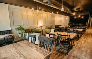
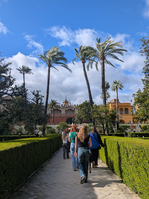
Cafes: I am a big fan of finding a nice little café to sit down and do some homework at or just spend time relaxing and people watching. One of my favorite cafes is The Lobby by Greyhouse, located in downtown Lafayette. This café is brightly lit and has a great menu of coffees, teas, and food options. Fair warning, however, The Lobby can oftentimes be crowded, and the menu can be a little pricey. If you are looking for a less crowded and more cost-effective option, try Vienna Coffee House, tucked away in Chauncey Square. Vienna has a variety of options and a quieter and more subdued atmosphere. Finally, if you are looking for something a bit more artistic, try Eleventh House, located in downtown Lafayette. Eleventh House prides itself on its bagels, and their walls are covered in community art/flyers. All three of these cafes offer a community hub to meet new people or catch up with old friends.
Libraries: You don’t need to spend money to find your perfect third place. Libraries have always been comforting for me, and I love finding a nice spot to work through homework or spend time reading. The West Lafayette Public Library blends nostalgia and accessibility for Purdue students looking to find a quiet area to study. By showing proof of a local address, you can attain a library card as a student and search among the rows of books for a good read, too.
Recreation: When I was a freshman, I wish I knew of more parks to spend time hiking or spend time outside. Although these parks are located a bit off campus, they are still within walking distance and are a nice sanctuary for those wishing to connect with nature. Celery Bog is located off of Lindberg Road, about a 7-minute drive from campus. However, there is a trail nestled behind the Northwest Recreation fields (by the Purdue University Student Farm) that connects CoRec-adjacent sidewalks to the trails of Celery Bog. Similarly, Happy Hollow Park is located to the northwest of campus, and if you follow the sidewalks on River Road all the way down (from South River Road to North River Road), you will find yourself at Happy Hollow Park. Don’t miss out on these great opportunities to hike trails, bird watch, or enjoy the sun.

Hobby spaces: One of my favorite places on campus is the Knowledge Lab, located on the third floor of WALC. This area offers free materials to all Purdue students, including sewing machines, a Risograph printer, a Vinyl cutter, a podcast booth, fabrics, and more, and they also offer workshops throughout the semester to teach you how to use the equipment or create different crafts. The Knowledge Lab also offers a large variety of crafting materials, such as felt, markers, stickers, hot glue guns, etc. The lab allows for experimentation across audio, visual, and textile media. If you are in a club and are in need of stickers or club t-shirts, the Knowledge Lab is the perfect place for you. During my junior year, I had a great experience using the podcast booth for a multimedia class project, and I would recommend trying it while you are here! Additionally, there is an art room located in the West Lafayette Public Library, and after reserving the room with the front desk, you gain access to their art and craft materials for free.

It is important to advocate for third places, as they offer increased function and connection within societies. Within this, it is also important to advocate for increased public transportation so that travel throughout third places becomes more accessible to all. I hope that my favorite West Lafayette and Lafayette third places have inspired you to visit somewhere new and make new memories!
By: Sara Zukowsky
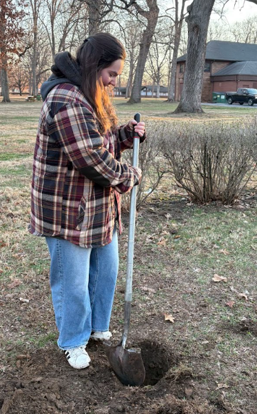
This semester, I had the opportunity to take NRES 497, our capstone course, and work with my group to design a rain garden for Battlefield Memorial Park.
Battlefield Park was experiencing erosion and sediment buildup in Burnett Creek, which runs downhill from the parking lot. Our team was tasked with designing a rain garden that our project partners could build to help reduce the amount of sediment entering the creek. To do this, we had to consider the amount of runoff the site receives and determine the size the rain garden would need to be to effectively manage that runoff.
Throughout the project, we completed many different steps in the planning process. We contacted 811 to ensure it was safe to dig in the area, performed a percolation test to evaluate soil quality, created a plant species list and educational materials, and developed both a maintenance plan and a cost estimate.
This project was an incredible opportunity to combine all of the knowledge I have gained throughout my time at Purdue. Not only was I able to apply environmental science concepts such as soil testing and plant selection, but I also used my experience in environmental education to help create educational materials for the project.
One of my main responsibilities was performing the runoff calculations. This helped us determine how much water the rain garden would receive and how much space it would require. To complete these calculations, we visited the site during rainfall events to observe how water naturally flowed across the area and how much runoff already entered the proposed site. We also measured the parking lot area and used EPA stormwater data to estimate annual rainfall amounts for the location. Together, this information allowed us to calculate the appropriate size of the rain garden to help minimize sediment pollution in Burnett Creek.
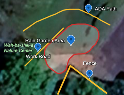
One image shows me digging during our percolation test, while another highlights the final shape and location of the rain garden design.
We recently presented our project to the class and will present it to the Tippecanoe Parks Board in two weeks before they move forward with implementation. Construction is planned to begin in the fall. Although I am sad that I will not be able to help build the rain garden myself, I am grateful to have been part of the team that designed it and contributed to a project that will benefit our community partners.
By: Paityn Freese
Similar to many NRES students, my reason for choosing the major was fueled by outdoor experiences I had as a child. My dad would take my siblings and me fishing, hunting, out to check trail cameras, and cut shooting lanes. My favorite parts were often tangential to the actual task at hand. I mostly enjoyed playing with worms, kissing fish, counting squirrels, etc. As anyone lucky enough to grow up outside will tell you, these opportunities often create a strong advocate for conservation and the environment. Over break, I had the chance to visit the origin of my love for the environment and go hunting with my dad. This experience was the perfect respite for an often-overwhelmed environmental science student. I encourage all my fellow NRES students to revisit what originally sparked their passion for the natural world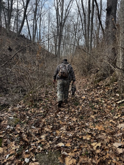 On an evening in early January, my dad and I set out to the tree stand we have shared a number of times before. The weather was mild for early January, but I am chronically cold. I layered three pairs of pants underneath my brother’s camo overalls and clutched handwarmers. I brought a book and the Merlin Bird ID app. I was prepared for a quiet evening, and if we were lucky–spoiler alert, we were not–seeing and even possibly harvesting a deer.
About 15 minutes into waiting in the tree stand, my book was interrupted by a few eager turkeys. Just behind the tree line, there was what sounded like a whole army of turkeys. I had forgotten the feeling of leaning forward, straining your eyes in dwindling light, hoping to catch a glimpse of something as wonderful as a wild turkey. In these moments, I was reminded of the excitement you uncover when stepping into the natural world. My memory was refreshed on the importance of advocating for the environment. The hungry turkeys reminded me swiftly of my motivations as someone pursuing a career in environmentalism.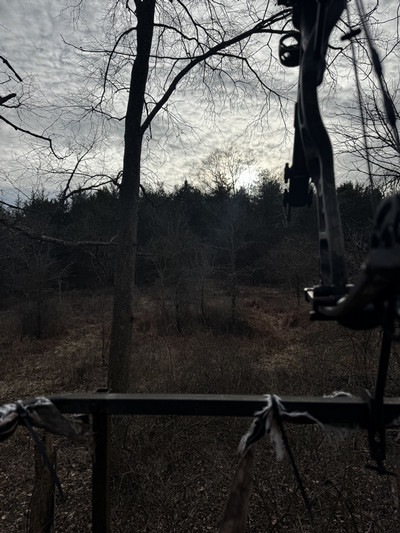 These days, I would not consider myself a hunter. Rather, I simply enjoy the wait that accompanies a spectacular gift from the natural world. With this in mind, I appreciate the contributions hunters make to conservation. I appreciate the desire to sit in the woods alone or with someone you love. I appreciate the desire to fiercely protect a world that gives relentlessly while requesting little in return. In Walden, Henry David Thoreau discusses the nuanced nature of hunting. He describes hunting as a gateway into a lifetime of appreciation of our natural world. For myself, it happened to work out this way. Sitting in the woods with my dad—waiting for simultaneously nothing and something—reminded me of my original “why.”
As students of the environment, it is easy to lose yourself in the deluge of bad environmental news. I think the most obvious and attainable way to counteract this is by returning to your origin. What first cultivated your passion for the environment? Remember that. Remember the feeling of the first time you caught a frog, counted the petals on a wild flower, or performed a stream health analysis. Pursue that giddy enthusiasm continually throughout your education and career. The persistent pursuit of your original “why” will propel you through the most challenging moments of a career in environmentalism.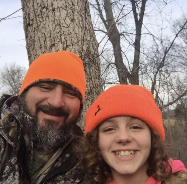
By Katelyn Bottando
Spring has sprung and so have many of the flowers around campus. You might be wondering about what kinds of flowers you can find and where you can view them. Well, you’re in luck! I am here to give you a breakdown of what they look like and where they love to grow.
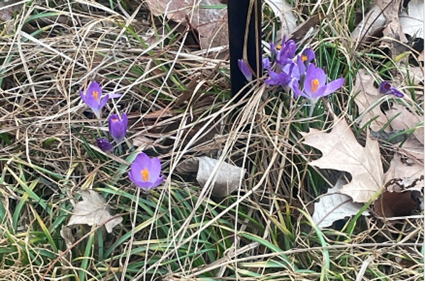
The very first place I would recommend is looking in the rain gardens on campus. If you’re not sure where they are, the Purdue Arboretum Explorer website can show you. One of my favorite rain gardens on campus is the one at the front of the Horticulture building. At this location, you can find a variety of pollinator plants, trees, grasses, and flowers. I found some Crocus flowers there just the other day (see below)!
The second place I would go looking is the wooded trail behind Horticulture park. Take the bridge over the creek and after walking for a bit you will find a wooded trail. It is there among the grasses that you can find trillium (below) and many others. Some can be trickier to find depending on the weather, but soon enough they will all emerge and should be visible from the trail.
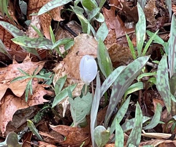
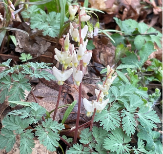
Lastly, the best place I know for viewing spring ephemerals on campus is McCormick Park. It is a bit farther compared to the other two, but it has so many beautiful flowers you can find. One of my favorites is called something rather silly, but upon further inspection you can see why. The spring ephemeral below is known as Dutchman’s breeches and springs up out of the ground in early spring.
If you’re worried you won’t find any - fear not! All of the pictures in this article were taken by yours truly last spring. Grab some friends and take a trip to see who can find the most spring ephemerals. To make things easier, I would recommend getting a plant identification app so you can keep track of all the different species you come across. This park also has a wide variety of fungi that grow on the trees and logs, so you’ll come across other interesting things along the way. Have fun!
By: Brooke Lederman
Entering college often means stepping into an unfamiliar world. While at times it can feel exciting, it can also feel overwhelming and isolating. Before coming to Purdue, I had lived in the same town my entire life. So, I found the adjustment especially challenging. Over time, however, I discovered that feeling at home on campus was really just about finding spaces where I felt grounded, comfortable, and connected. These places, extending beyond the routine of attending class and returning home, profoundly shaped my college experience. As I approach graduation, I want to share a few of the places that transformed Purdue into a home for me.
In recent years, the concept of a “third place” has gained popularity. Coined by sociologist Ray Oldenburg, the term refers to a social environment separate from home and work (or school) where people gather, relax, and build community. For me, that third place became Vienna Espresso Bar & Bakery, the coffee shop on the corner of Chauncey Street and State Street. Whether I needed a quiet place to study, a quick coffee between classes, or simply a minute to decompress with friends, Vienna offered consistency and comfort. Over time, I formed friendships with other regulars. Sitting on the patio beneath the redbud tree on a sunny afternoon has quickly become one of my favorite simple pleasures.
Purdue and the surrounding area offer plenty of other inviting coffee shops worth exploring as well. Lavazza serves what I consider the best coffee on campus, and Greyhouse Coffee & Supply Co. provides a warm, cozy atmosphere perfect for conversations with friends or long study sessions. Eleventh House houses incredible community art and some of the best café food I’ve experienced in my time here. Each of these places offer opportunities to find community and recharge.
Another unexpectedly important space for me was the France A. Córdova Recreational Center, known as the CoRec. Before arriving at Purdue, I did not anticipate spending much time at the gym. Now, I find myself there almost daily. Beyond its extensive workout equipment and weight rooms, the CoRec offers free group fitness classes for students. I have especially grown to love the yoga classes, which I go to at least twice a week. The hour I spend in class provides me with a much-needed pause from academic pressures, allowing me to reset both physically and mentally. It also serves as a social outlet. Inviting friends to join a class or meeting familiar faces who attend regularly transformed the activity into something communal and gave me something to feel a part of.
Equally important has been finding “my” study spaces that give me a sense of calm, particularly when academics begin to feel more demanding. One of my favorite locations is what has become known as the “Jedi Room” on the seventh floor of Beering Hall of Liberal Arts. The nickname comes from its floor-to-ceiling windows, which wrap around the room, giving a view of the entire campus. Having a space that I love makes even more painful work feel manageable. I have also spent lots of time in the study rooms in Rawls Hall and the Parrish Library on the second floor of Krannert Building. The lobby of the NRES building (FPRD 101), is always a reliable place to work or pause between commitments. There are so many buildings to explore to find the study spots that are a perfect fit for you and your study habits. Discovering these environments can make a world of difference when managing your workload throughout college.
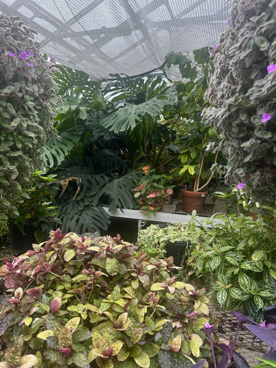
Finally, seeking out natural spaces has been essential to my well-being. Happy Hollow Park, about a twenty-minute walk from campus, offers paved and wooded trails, open grassy fields, and sand volleyball courts. Whether I have wanted to take a walk alone and get some fresh air, or gather friends for an afternoon outside, the park has consistently provided me with a restorative and enriching break. During colder months, when outdoor time feels less appealing, I’ve often found myself visiting the greenhouses in the back of Lily Hall. Although not every greenhouse is open to visitors, wandering through the accessible hallways and plant-filled rooms brings a sense of calm that is difficult to replicate. Working in one of the labs that maintains these spaces deepened that connection for me, offering regular interaction with the natural environment. Spending time among these plants has steadied me more times than I can count.
Ultimately, feeling at home at Purdue did not happen all at once. It emerged slowly, from exploring these unfamiliar spaces and allowing them to become familiar. My advice to students that are just starting out or that are feeling out of place is to seek out places that resonate with you, both on and off campus. The right environment can foster friendships, support mental and physical health, and provide moments of stillness amid academic demands. You may be surprised by what places and activities you end up falling in love with.

By: Eva Morie
Over Spring Break, I visited fellow NRES students Joe Slover and Ellie Payne in Ireland. I had the privilege to immerse myself in Irish culture and hear about their experience abroad. Joe and Ellie are currently doing the semester abroad exchange hosted through the University College Dublin in the Agriculture program. As the largest university in the largest city in Ireland, the university provides world-class academics and a wide range of degree options within the faculty of agriculture. The university is also ranked in the world’s top 50 for sustainability, making this opportunity especially practical for NRES students.

After visiting the campus, I interviewed Joe and Ellie to gain more insight into their experience in the program. I started by asking them how their study abroad experience has been so far. Ellie said that like any semester there are highs and lows and that she’s experienced some challenges transitioning to a new routine. She also said that she never thought that she would have access to the world in the way that she does now, “If I have free time I am able to easily explore downtown Dublin, other parts of Ireland, or book an inexpensive flight to surrounding areas like Europe and Africa”. This semester Joe and Ellie have been all around Ireland traveling to Dingle, Galway, Kerry, Waterford, Howth, and County Clare. Beyond Ireland, they’ve traveled to Copenhagen, Wales, Brussels, Paris, and Italy. Joe said that their favorite part about studying abroad is this ability to gain a greater perspective on other cultures and compare them to our own along with the ease of traveling. The university has aided some of their travels from field trips through Europe, and to places like Hometree, a charity in west Ireland focused on conserving and restoring native landscapes.
Next, I asked Joe how studying abroad in Ireland is advantageous for NRES students. They said that their classes allow them to visit various unique ecosystems and learn how other cultures manage their natural resources. They also said that studying environmental science abroad is especially advantageous because it provides a diverse, international perspective on global climate issues, policy, sustainability, and resource management. Diversifying your perspective makes you a stronger candidate for natural resource jobs, as many environmental problems don’t have a single approach. Understanding international methodologies equips students with a complex, multifaceted approach to environmental issues.

Purdue provides a multitude of time lengths for study abroad, including winter sessions, spring break, short-term summer, long-term summer and full semesters. Ellie chose to do a semester abroad because it aligns with her career goals, “I have always wanted to do the Peace Corps and studying abroad is an important pre-cursor". The exchange program enables deep cultural immersion and greater personal growth opportunities while navigating the world individually. Joe said the exchange program allows for a lot of freedom, while other study abroad programs are planned for you. When deciding which program to participate in, Joe recommends figuring out your priorities and goals first. One of Joe’s goals was to “see a lot of Europe and see how European policy is carried out in various cities and communities”. Understanding your priorities, like independence and traveling for Joe, along with attending callouts and researching countries are extremely helpful for discerning your study abroad program.
After spending a week in Ireland, I used a lot of public transportation to explore and go sightseeing. From my experience, Irish infrastructure was very accessible. I rode on the buses to travel around Dublin, the trains to get to Galway, and another bus for the Cliffs of Moher. Public transportation is heavily adopted by locals, and Joe said it's crucial to speak to locals for an authentic experience. We received many recommendations for restaurants, hikes, deals, and sights. Joe recommends visiting Dingle to bike the Slea Head Drive and hold a baby lamb. They also recommend The Cobblestone for traditional music, and they also host dance lessons on Mondays.


Since NRES assesses global issues and is an interdisciplinary study, I feel that studying abroad is so valuable. Joe and Ellie encourage all students to consider studying abroad. From my perspective, the environment is changing so rapidly and there is so much to learn from other countries to be an adaptable and knowledgeable steward of the Earth. Purdue provides once-in-a-lifetime opportunities that encourage immersive learning and diverse perspectives that are extremely advantageous for NRES students.

By: Elina Gorenstein
Have you been wondering what a week in the life of a research technician looks like? Or maybe, wondering if research and academia is the field for you? In the summer of 2025, I worked with Dr Sidd Paul in the Purdue Agronomy Department as a research technician. I worked with a fellow NRES student on a project called the ION Project. The ION Project is a large, multidisciplinary project looking at organic farms in Indiana (ION = Indiana Organic Network!), but my lab’s focus in the project was on digital soil mapping, GPS data collection, and soil organic carbon accumulation. If you’re going to work in any form of soil research, I’d recommend you start as soon as possible after finishing NRES/AGRY 255/270, because you’re going to really solidify your soil science foundation by applying the work from the classroom!
A typical week for us looked like 1-2 days in the field (sometimes more, if our field site was close to campus), and the remaining days in the lab or office either analyzing sample or processing data. The day before fieldwork, we’d make sure everything was packed and ready to go for an early start the next day. We’d bring sample tins, plastic bags, soil probes, charge all our field iPads, charge the drone, its batteries, and our GPS. Sample bags had to be labeled with intended points, data sheets needed to be set up, and we also had to coordinate with other labs if we were borrowing other technicians for the sampling. Sometimes, we’d have to call the grower to finalize logistics. Sounds easy, right? Not quite – a lot of the growers I worked with were Amish, so getting in touch with them wasn’t all that easy! We’d also make sure the lab truck was ready to go and had enough gas and air in the tires to make it there and back
Field days started early for us! I was usually up around 4:30 to be in the lab by 5:30, and we’d usually leave campus around 5:45 or 6 in order to beat the heat. Once we were in the field, we would split up into groups of two or three to collect samples, while one person walked through the field marking exact sampling locations with our GPS and putting a flag in the point. We had to get creative when sampling soil in a corn field in late July, when it was over our heads, and used go-kart flags to mark our intended points. I didn’t realize just how disorienting tall corn is! After a couple of hours sampling, we’d hide in the truck for lunch during the sunniest part of the day. This is also when we’d fly the drone, as we needed to be out of the field while it was flying. It would take images of the soil below us, which can then be used to make a map of the soil to hyper-target recommendations to the grower. After lunch, we’d continue sampling until we ran out of bags or 5 pm, whichever was first. Once we finished for the day, we’d count all of the samples, ensure none were missing, pack them into the truck, and head home.

The next morning, we’d get to work and start processing samples. Per our protocols, this meant weighing everything, recording the weights, and then part of the sample would go into the oven to bake, then got reweighed to find their moisture content. The other samples would be dried, then ground up, then sent to a lab for chemical analysis. We’d also make sure our samples corresponded to what we recorded in our field iPads. Usually, we’d also discuss our next sampling day and the whole process would restart.

If you’ve ever been even a little curious about participating in undergraduate research, you should do it! I found this position by asking around the agronomy department to see who was hiring. I learned so much about field work, which helped reinforce the skills I’d built in NRES 338, Environmental Field Skills, too. This summer was an incredible learning experience, and I thoroughly enjoyed my time.
 By: Anna Sorg
February 20 and 21st marked the first ever LightsUp Conference, a conference focused on bringing together students and professionals in the area of sustainable energy. LightsUp is the first energy conference of its kind at Purdue- it is fully developed, coordinated, and staffed by students within the sustainable energy club. The inception of LightsUp began with a dream. Johanna Walther, Kaashvi Mehta and myself, had the idea of creating a space where students, researchers, community organizations, and industry professionals could come together to celebrate innovations and individual action within the sustainable energy field. Now, through the dedication of the LightsUp Committee, this dream is a reality. We created this conference to cultivate LightsUp moments: the feeling of learning something new, the spark of making a connection, the light bulb moment.
During the first day of the conference students got the opportunity to engage with renewable energy industry leaders through a panel of guest speakers which included Lisa Berry from GE Vernova, Mark Schuler from RWE, and Ryan Henderson from Hoosier Energy. The panelists gave insight on the future of renewable energy explaining that the industry will need to take an ‘all of the above’ approach, meaning energy producers will need to diversify their portfolios of clean energy.
The second day of the conference began with a keynote speech from Dr. Kevin Kircher, who explained the need for shifting to renewable energy and the potential we have as individuals to engage in policies that support clean energy. Next began a lightning talk session with Dr. Jay Gore discussing bioenergy, fossil fuels, and nuclear energy. The second and third lightning talks were given by Dr. Travis Horton who explored new technologies and techniques for sustainable infrastructure development, and two graduate students, Geoffrey Sanchez and Jabir Bin Jahangir who explored the intersection of energy and agriculture through agrivoltaics.
The afternoon sessions kicked off with a concurrent outreach room, virtual reality simulator room, and poster session. The community outreach room had 14 organizations from across Indiana that students were able to network with and learn from. The virtual reality simulation explored the food-water-energy nexus by having participants make decisions on their consumption habits and then portraying the rising water levels on Liberty Island that resulted from carbon emissions created from their choices.
Overall, I was extremely proud of how well the conference ran, having over 100 attendees. It was a great experience in learning how to plan large scale events and how to communicate to a mass audience!
By: Marley White
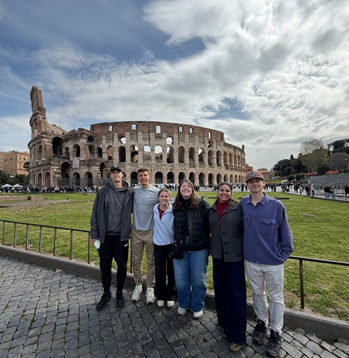
For spring break in 2024, I went on a study abroad trip through the John Martinson Honors College, during which we traveled to three amazing cities in northern Italy. These cities were Padua, Verona, and Venice. One unique aspect of this study abroad trip was that it focused on intercultural learning by partnering us with a group of students from the University of Padua. With this group, we completed a project on climate change, both in Italy and through an online class taking place before and after the trip, bridging our two different cultural perspectives on this issue. They also hosted us in Padua, providing us with the special opportunity to learn about Italy from the perspective of students living there. Here are some of my favorite parts of the trip!
First, one of the most fun parts of this trip was spending time with the Italian students at the University of Padua. These students showed us around Padua, introduced us to their favorite food spots, brought us to their dining hall, and even took us to a few of their classes! We would also spend time with them in the evening, such as attending their movie club’s showing that week or just getting gelato with them after dinner.


Another highlight of this trip was visiting Verona, Italy, where the famous story of Romeo and Juliet took place. Here, we walked around the city, visited beautiful gardens, and saw a Roman amphitheater (which is older than the Roman Colosseum!). We were also able to learn more about how the food in Italy differs from region to region, or even city to city, with Verona offering meat such as horse or donkey that did not appear on any menus in Padua. This visit was just a day-trip, but we were all amazed by the beauty of this city.


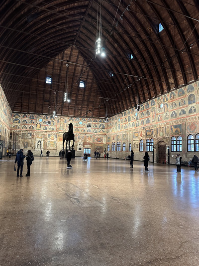
The final highlight of our trip was visiting Venice. We stayed here a few days, allowing us to explore the rich history and unique architecture of the city. This included touring the famous St. Mark’s Square and the Basilica of Saint Mark, exploring the various canals with a guided walking tour, taking a boat to Murano Island (famous for its centuries-old glass-making tradition), and, of course, trying more of the delicious food of Italy. My favorite part of exploring Venice was seeing the mosaic artwork in the Basilica of Saint Mark, with many of these mosaics containing layers of gold leaf and covering almost all of the walls inside the basilica.


Overall, this spring break trip was a wonderful experience, during which I learned about Italian art, culture, food, and even the students' personal perspectives. Specifically, through our group project on climate change, I was able to learn that Italians typically view climate change as an issue to address through lifestyle changes on the personal level, while Americans typically feel that changes should come through government policies or corporate change. I recommend studying abroad in Italy to everyone!

By: Anna Sorg
In light of the ongoing moratorium for utility scale solar in Tippecanoe County, student organizations and non-profits such as the Sustainable Energy Club and Solar United Neighbors have organized campaigns to spread awareness on the benefits of utility scale solar in Indiana. Here are three common myths and rebuttals for utility scale solar.
The first solar myth is that solar farms create glare: Manufacturers utilize anti-reflective coatings on panels that manipulate and reduce the amount of light that bounces back off the surface. The glass surface is textured to diffuse the light reflected instead of a concentrated beam. Studies show that the following are more reflective than solar panels: asphalt, standard window glass, water, and snow. In the new subsection proposed in UZO chapter 4, alternative 1 suggests that large scale SES shall not exceed 0.5 footcandles, yet at mid-day in no shade the sun emits 10,000 footcandles, which causes 20,000 times more natural glare.
The second myth is solar creates heat islands: A study by the University of Arizona found that the temperature of soil in full midday sun is often hotter than the same soil under panels. Additionally, per a study by the National Renewable Energy Laboratory, planting native seed mixes below solar arrays will absorb heat naturally and ultimately, support the soil health.
The third solar myth is that the citizens within Tippecanoe county are against utility-scale solar development. For the past 5 months I have been participating in deep canvassing and phone banking to gauge awareness and support of the citizens of Tippecanoe county. Many citizens I have interacted with were in support of utility-scale solar when implemented in a sustainable way, which is why it is important that the decisions made by the Area Planning Commissioners reflect the sentiments of the constituents they represent.
By: Aaliyah Carlisle
The spring semester has been a long one, and in the afternoons, one of my favorite ways to
unwind is with a nice, crisp Dr. Pepper. My love for Dr. Pepper started in college and has grown
almost similarly to how most people in college love coffee. Over this past spring break, I had the
chance to visit the beloved Dr. Pepper Museum in Waco, Texas.

This museum is very interesting; it walks through the invention of sodas and how they were first
used as medicine. It has the history of Dr. Pepper, including how it was first made in a
pharmacy. And the best part (besides the free Dr. Pepper you get at the end) is their section on
water sustainability. There was an entire section titled “Water is life.” This section really broke
down how water is used in the soda manufacturing industry. Water is one of the biggest
ingredients when it comes to soft drinks. It’s used for cleaning, and perhaps the most fun is the
use for carbonation. The section dedicated some of its space to telling museum goers what they
can do to contribute to clean water, things like disposing of waste properly and reducing
personal environmental impact.

The Dr. Pepper Museum is one of the first places where Dr. Pepper was industrially made and
bottled. Because of this production, they had to have access to a well. The well is still visible in
the museum today, and it has dropped over 70 feet from the original level due to production.
Seeing it is a great way to visualize just how much production occurred at that location.
 The black line of the well is where the water was originally, and 70 feet down is where the
current water level is.
While all of this is cool to acknowledge the history, the best part for me was to be able to see
what Dr. Pepper is doing right now to help conserve water. Keurig, which owns Dr. Pepper,
acknowledges that they have a responsibility to help address global water changes. They have
interesting management approaches to keep track of their progress towards their goal of net
positive water impact by 2050.
After visiting the museum and going through the website, it feels good to know that when I drink
Dr. Pepper, they also have the environment in mind with their production. It’s really got me
thinking about the rest of the brands I like to consume. Does it for you?

By: Grace McRoberts
I spent junior second semester abroad in the wonderland that is Norway. Two months into my time, I wasn’t hiking through fjords or exploring landscapes the way I had imagined. Instead, I was learning how to walk again. Tearing my ACL that early into my study abroad experience wasn’t part of the plan. As an avid explorer, I had envisioned months of hands-on learning, outdoor exploration, and seeing environmental systems up close. This plan got derailed on a ski trip one perfect afternoon.
In Norway, nature isn’t something separate from daily life, it’s integrated into it. Even while recovering, I could see how infrastructure, public spaces, and cultural values made the environment accessible. Trails, public transportation, and urban design all seemed to reflect a deep respect for the natural world. People didn’t just visit nature; they lived alongside it, which was perfect for me. The busses went to end of the ocean, so I was able to continue learning whilst on crutches.
My injury, while frustrating, forced me to engage with these environments differently. Instead of constantly moving, I spent more time observing. I paid closer attention to how people interacted with their surroundings, how they commuted, where they gathered, and how environmental choices were embedded into daily routines. It also made me reflect on the relationship between people and place, which is at the core of environmental science. Back at Purdue, much of my learning focuses on ecosystems, conservation, and resource management. Abroad, I saw how those ideas play out in real life, how policy, culture, and design shape environmental outcomes in ways that aren’t always obvious in a classroom.
Recovering in a different country also highlighted differences in pace and priorities. There was a stronger acceptance of slowing down, of taking time to heal, and of not always pushing forward at full speed. That mindset shift stayed with me. It changed not only how I approached my recovery, but also how I think about sustainability, because sustainability isn’t just about protecting resources, it’s also about creating systems that support long-term well-being.
Studying abroad didn’t go the way I expected. I didn’t get to experience every hike or every field opportunity I had planned. But in many ways, I gained something more valuable: a new perspective. I learned that sometimes stepping back, whether by choice or circumstance, can deepen your understanding of the world around you. And as I continue my work in natural resources and environmental sciences, I’ll carry that perspective with me: that how we design our environments, and how we choose to live within them, matters just as much as the environments themselves.


By: Hanna Dykema
My name is Hanna Dykema, and this spring semester I had the incredible opportunity to study abroad in Madrid, Spain. While “life-changing” may sound cliché, it truly is the best way to describe the experience. Spending a semester abroad challenged me, broadened my perspective, and deepened my appreciation for culture, community, and sustainability in ways I never expected.
As a double major in Natural Resources and Environmental Science (NRES) and Economics, choosing a study abroad program was not easy. Purdue offers so many incredible opportunities, and I wanted a program that would support both my academic and personal interests. Ultimately, I decided on an exchange program through the School of Business at Universidad Carlos III de Madrid.
From the moment I arrived, Madrid felt different from anywhere I had experienced before. The city moves at a slower, more intentional pace. People linger over meals, conversations continue late into the evening, and daily life seems centered around enjoying the moment rather than rushing to the next task. It was refreshing to experience a culture where community and connection are woven into everyday life.
Spanish culture itself is incredibly vibrant, and it was inspiring to see the pride people have for their traditions and history. Throughout the semester, I experienced this in so many ways — from flamenco dancers filling the streets of Seville with music and movement to the city-wide celebration of San Isidro, Madrid’s week-long festival honoring its patron saint. No matter where I traveled, there was always a strong sense of identity and celebration rooted in local culture.
The term “exchange program” could not be more accurate. This semester became a true exchange of ideas, traditions, and perspectives. While I answered plenty of questions about American universities, Buc-ee’s, and fall traditions in the United States, I also learned about the French education system, social customs in Estonia, birthday traditions in the Netherlands, and so much more.
Some of my favorite memories came from the dinner nights my roommates and I hosted together. With roommates from France and Italy, we each took turns preparing meals and desserts from our home cultures. These evenings became more than just shared dinners — they were opportunities to connect, learn from one another, and experience culture in such a personal and meaningful way.
Although most of my coursework focused on Economics, sustainability and environmental awareness remained a constant part of my experience abroad. Madrid’s extensive public transportation system, the walkability of the city, and the emphasis on reducing waste in daily life all reflected values that aligned closely with my NRES background. I found myself paying closer attention to how people interacted with and cared for their environment, whether through the city’s well-maintained public parks, community gardens, or everyday lifestyle choices.
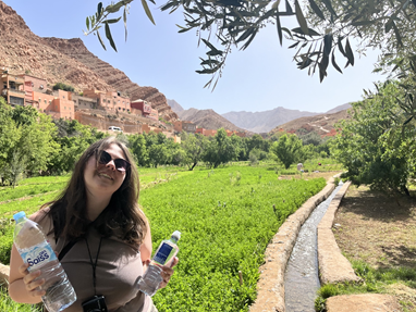
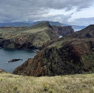
Traveling throughout Spain and beyond made those observations even more meaningful. Every place I visited seemed deeply connected to its natural environment. Along the coast of southern Spain, the ocean shaped local food traditions and daily life. In Madeira, Portugal — home to many endemic plant and animal species — crops like sugarcane and bananas have long influenced both the economy and landscape. In Morocco, climate affects everything from breathable clothing design to irrigation practices and architecture.
Experiencing these differences helped me realize something important: natural environments do not simply exist alongside culture — they actively shape it. Even though my classes abroad were not directly related to NRES, I constantly found myself making connections between people, place, and the environment. Those moments made the experience even more impactful.
Looking back, studying abroad pushed me far outside of my comfort zone in the best possible way. It taught me how to adapt, take initiative, and embrace unfamiliar experiences with curiosity instead of fear. Most importantly, it left me with a greater appreciation for the diversity of people, cultures, and environments that make up our world.
If you ever have the opportunity to study abroad in any capacity, I would absolutely encourage you to take it. You may leave with new academic experiences, unforgettable memories, and stamps in your passport — but more importantly, you will return with a new perspective on the world and your place within it.
Fall 2025 Blogs:
By Anna Sorg
Time management is key for a successful semester and career, whether you are blocking out time to study, or jotting down new events, it is important to have a system that works for you! Juggling all of your responsibilities can seem daunting, especially as a college student, but with the right tools, you can make your schedule work with you instead of against you.
Some general pieces of advice would be to input all of your assignments within the first week or two of school so you are never jumpscared by an upcoming assignment. The second piece of advice would be to write down the dates and times of all of the events you are interested in even if you don’t fully intend on going. The start of each semester is hectic with callouts and fairs, it is best to have all of these events on your radar so you know what to pick and choose from and to stay informed about happenings on campus. The final piece of advice would be to choose a day to update all of your calendars. By designating a time to keep everything up to date, you are making a habit to stay consistent. Being organized is a learned habit, not something that comes naturally! Give yourself grace, and with time, you will succeed.
I want to preface by saying that time management is highly specific to each individual, and it takes practice and time to find a style that works for you. In my own journey (my very long, 6 year, ongoing journey…) of finding the perfect calendar, I have tried so many resources, schedules, and calendars, so I wanted to share my top five tools and tips to set you up to thrive this semester!
1. Google Calendar
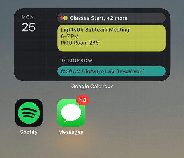
My tried and true gem of a calendar. Google calendar is super helpful for keeping track of all of your events e.g. club meetings, classes, trips etc…. This app/website is a great base layer that can act as a ‘meta’ calendar, meaning it is a good go-to resource to get a general overview for your week, month, or even year (if you’re ambitious)!
Tips:
Use the “Other Calendars” function to add specific calendars correlating with your clubs, classes, labs, or work! This function allows you to toggle your calendars on and off so you don’t get overwhelmed by the amount of events you have on your main view calendar.
Subscribe to your brightspace and outlook calendar! Most websites/apps have an option to ‘subscribe’ to your calendar. Copy the URL from your app of choice, and add it as an ‘Other Calendar’ on Google Calendar to get a cross-website view of all your events!
Make a widget on your iPhone. If you are an apple user, you can make Google calendar a widget on your iPhone! This is an easy reminder for the upcoming events you may have in the near future.
2. Shovel
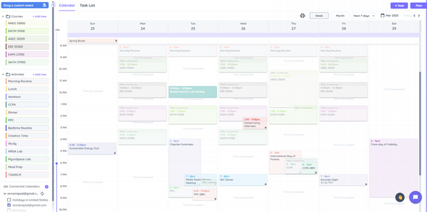
Don’t skip out on this resource! Purdue students get free access to Shovel when you sign up with your school email. Shovel is a great tool for blocking out time for events, but also blocking time for studying! Once you sync Shovel with Brightspace, your assignments automatically generate into the website/app. With its easy-to-use interface you can drag and drop assignments into your calendar to carve out assignment-specific study time.
Tips:
Make recurring events a time block. On the website, you can make blocks of events that occur every day like lunch or working out. From there just drag and drop them into your schedule!
Download the app! There is an option to get notifications of upcoming events right to your mobile device so you never miss a study session or a study break!
Don’t forget assignments. Sometimes professors don’t upload assignments under the ‘Assignments’ tab of brightspace, so they won’t populate in Shovel. Do not forget to consistently check brightspace for upcoming assignments!
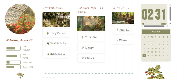
3. Notion
Ahh notion, how I love you so. Notion is an all-in-one dashboard that allows you to build your own templates for just about anything: assignment tracking, habits and goals, budgets, and so much more! If you find the ‘building’ portion of this website intimidating -- not to worry! Notion offers hundreds of free templates for just about anything you can think of. Personally, I love Notion because there are so many cute and creative templates to choose from, and they are all extremely customizable to cater to your own vibe. Typically, I use Notion for assignment tracking, weekly tasks and to-do lists so all of my thoughts and plans are in one location.
Tips:
Find a vibe that fits you! Notion has so many templates, I recommend finding an aesthetic that resonates with you so it is enjoyable to prepare for your week.
Don’t overthink it. It is easy to get overwhelmed with everything Notion has to offer. I recommend starting with something you know you’ll need, like a simple to-do list or an assignment tracker, and slowly build more tools into your dashboard.
Start early. By starting your dashboard at the beginning of the semester, you will be able to visualize all of your tasks. This way, you can start to delegate timeframes for them as they pop up.
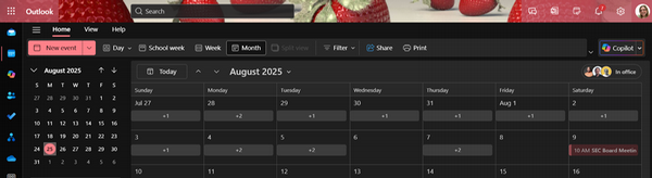
4. Outlook Calendar
I find the outlook calendar most beneficial for work/lab and club related events (again, this is a personal preference, and if you prefer to use it as your main calendar, go for it)! It is important to become familiar with Outlook because it is the main communication tool used in all industries; private, non-profit, and government. Personally, I use Outlook to schedule my lab and club meetings because it is easy to invite people to your meeting via the ‘Create New Event’ button. Simply click this button, name your meeting, invite your attendees, and viola! You have successfully created a meeting!
Tips:
View other people's calendars. Everyone is busy, and finding meeting times is a hassle! With Outlook calendar, click the hamburger menu, in the side panel that appears click ‘Add Calendar’ at the bottom. In the pop-up window click ‘Add to directory’ on the side panel, and type in your professor or boss’ email. Now you can see their availability, and find a meeting time with ease.
Make Teams meetings. When you organize a meeting, there is automatically an option to make it a Teams meeting.
Customize! Customize your Outlook by going to settings > general > appearance. Now when you open the website you will have a splash of personality!
Physical Planner
There’s a reason why planners will never go out of style, according to Oxford Learning, the process of writing by hand reinforces memory pathways. Finding the perfect planner can be intimidating, but I suggest thinking of how you want your planner to serve you. Do you want to only write down all of your events and due dates? Look for a simple monthly calendar that allows you to fill in events day-by-day. Do you like writing to-do lists each day? Look for a calendar that has writing room for each day with a monthly calendar view. For purchasing a planner, go in with the intent of how you will use it, and find a style that works!
Tips:
Color! Color coding your calendar not only triggers your brain to make connections between tasks, but it also livens up your page!
Bring it everywhere. By bringing your calendar with you, it makes it easy to write down events as they come up.
Always check in. When you consistently check your calendar, it builds your confidence since you know exactly what to expect every day, and it makes it easier to pivot when plans change.
Whether you prefer online organization or old fashion functionality, there is a system out there that works for you! Combine and customize your own time management system by using the tools I have suggested, or use it as inspiration for forge your own path. Organization is a habit, if you stay consistent, you will get the results you want. Happy planning!
Originally posted 8/27/2025
By: Grace Collins
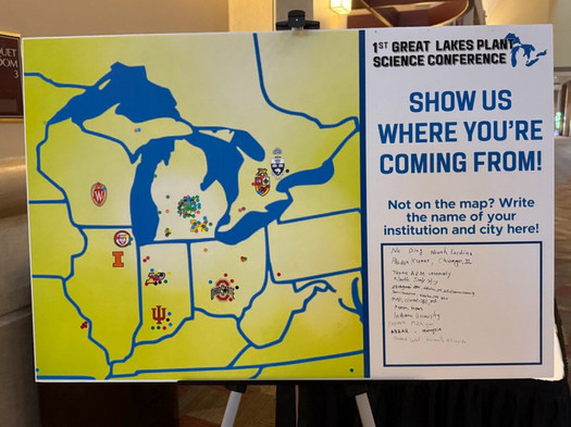
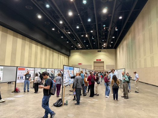
This past weekend I had the great opportunity to attend and present a research poster at the 1st Great Lakes Plant Science Conference hosted by the Michigan State University Plant Resilience Institute. The conference itself was split into three main sessions: Plant Science in a Changing Climate, Biotic Interactions, and Integrative Omics, Systems, and Synthetic Biology Approaches. With over 212 posters, 10 exhibitors, 55 institutions, 28 talks, 6 industry partners, and international attendees, I was able to integrate myself into a community of plant science professionals who are passionate about using innovative research techniques to improve ecosystem resilience.
The conference began with a series of presentations and flash talks within each of the three conference sessions. During these talks, I was able to listen to researchers discuss their current work in plant science. Some of the topics covered included plant-microbiome and microbe-microbe interactions; dual roles of plant species in different locations; space radiation effects on plant microbiomes; molecular dynamics behind photosynthesis; and more! As an audience member, I was able to expand my horizons into the techniques and applications of plant science, and I felt truly inspired by other scientists’ work.
After listening to the presentations, it was time to present my poster! I presented on a project that I have worked on over the past year with Dr. Morgan Furze under the departments of Botany and Plant Pathology and Forestry and Natural Resources. The poster presentations were split in half between two days, so while I spent Saturday evening discussing my research, I was able to look at the rest of the posters the next morning. I really enjoyed being able to practice my scientific research communication skills to people who are passionate about plant science, and it was also very exciting to hear about the projects that others have put their time and passion into.
On the last day of the conference, there was an industry panel with representatives from Plastomics, CTC Genomics, Thermo Fisher Scientific, Pairwise, and Inari Agriculture. The panelists discussed how to prepare for a switch from academia to industry, what the industry culture is like and what is expected of you in these roles, and what setbacks or benefits you may expect within industry. By listening in on this panel, I gained a deeper understanding of how those who are interested in a career in plant science are able to apply their experience to other sectors and move between different roles.
With this being the first Great Lakes Plant Science Conference, it is hard to predict what the conference will look like in the future. However, I strongly encourage everyone to apply to register if able, especially if you are interested at all in plant science! It is not a requirement to present research at the conference – it can be a great opportunity to learn about ongoing research in the field and connect with others. Although the conference was largely populated by graduate students, there were many undergraduate students there as well. Food was provided by the Plant Resilience Institute, and the attire was primarily business casual. Although there was a registration cost, Purdue’s Center for Plant Biology has offered to cover the cost, and a Travel Grant awarded through the Plant Resilience Institute at MSU covered the entire cost of the conference including travel, extra food purchased, and lodging.
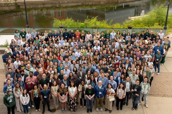
One of the key takeaways from the conference was how investment in plant science in the Great Lakes region is critical for the prosperity of North America. I am so grateful that I was able to attend this conference and surround myself with those who are passionate about integrating fundamental and applied sciences to benefit plant ecosystems. I am excited to see how this conference is built over the years and what legacy it will hold in the Great Lakes region!
Originally posted 9/22/2025
Growing up in rural Indiana, farmers were—and still are—the champions of my community, representing what it means to be a steward of the land. The management choices of farmers often reflect the culture of rural America.
Daryl and Judy Drake, regenerative farmers from southeastern Indiana, represent both a divergence from and a connection to the stereotypical farmer. While their management choices are distinct, their convictions behind regenerative production are the same set of values leading many farmers to choose conventional methods. For farmers who share the same values as Daryl and Judy, the choice to farm a certain way is more than mere methodology—it is an expression of identity. Their faith, commitment to family, and belief in stewardship shape how they manage their land, blending values with practice in every decision.
To best understand how the Drakes live out their values, it is important to have a grasp on what regenerative agriculture is. Regenerative agriculture describes farming as returning more to the land than what is removed through planting, growing, and harvesting a crop. Farming regeneratively requires a holistic approach to production, increasing soil health, water quality, and biodiversity. The idea of regenerative agriculture as a climate-resilient solution to the many problems faced in modern agriculture is growing in popularity among producers. Farmers are stewards of the land, creating a strong desire to preserve and improve the land for future generations. This strong sense of identity and its connection to land management choices makes the values behind production integral to decisions on the farm.
The Drakes wear the regenerative label with pride. Motivated by their faith and a desire to continually improve, they seek out experiences that inform their farming decisions. They have often been early adopters, even one of the first in Franklin County to implement cover crops and no-till practices. It was at a conference that they first learned of regenerative practices. Later, at a farm visit in Tennessee, they began to hear more about the processes that naturally fill the soil with nutrients and loosen it without traditional tillage or fertilizers. The couple, whose faith guides their stewardship decisions, saw these new methods as a way of farming that removed themselves from the land and added God back to it. This spiritual outlook on production illustrates a distinct why behind the methods on the Drakes’ farm.
On a phone call with the couple in late April, they took a few moments to describe their surroundings. Sitting on the front porch of their farmhouse, they spoke of the setting sun sending beams of light dancing over blades of grass in the spring-green field across from their home. A hooting owl framed our conversation, representing a solution to a vole problem in one of their fields. Here, Daryl spoke to the heart of the couple's stewardship decisions. “We live and work in God’s creation,” Daryl explained. “We see His miracles every day.” Farming regeneratively, Daryl and Judy recognize the miracles in the seemingly mundane. Judy reflected momentarily on how most farmers are in awe of creation, remarking that there “is certainly faith on the farm.”
Regenerative practices promote soil health by reducing inputs and increasing the cycling of nutrients through the soil.The couple describes leveraging natural soil processes to decrease their impact on the land. Deep-rooted cover crops limit the amount of tillage necessary. Moving away from conventional monocultural farming, their operation uses diverse plant species that return a variety of nutrients to the soil. Noting their success at improving soil health, Daryl shared an anecdote about no longer needing to buy bait when he goes fishing. Instead, he goes to his field, finding plenty of worms there.
When Daryl and Judy first adopted regenerative practices five years ago, the closest farmer with a similar operation was in Columbus, Ohio, about 2 hours away. Today, though, two farms in surrounding counties also farm regeneratively. Still, what is striking about their operation is not the uniqueness of their methods. Instead, it is the familiarity of their motivations. What sets the Drakes apart is not why they farm but how they have chosen to live out their values. Prioritizing stewardship in a way that reflects their identity as Christians and parents is not unique to regenerative farmers. Their purpose-driven approach connects them to neighbors who share similar convictions—reminding us that in rural communities, farming is as much about values as it is about techniques.
This essay was a submission to the Townsend Communication in Agriculture Competition through Purdue’s College of Agriculture. The goal is to encourage better scientific communication between people and scientists. This essay won an award for outstanding communication within the competition. Find more information here:
https://ag.purdue.edu/department/asec/townsend/index.html
Originally posted 10/2/2025
By: Marley White
Applying to law schools can be a daunting and challenging task, but this stress can be mitigated through proper planning and preparation. While I am not yet finished with my law school application journey, here are some tips and resources that will make applying to law schools easier and less overwhelming.
First, plan ahead and set goals for yourself! One of the most difficult aspects of the law school application journey is just deciding where to start. Besides planning to take the LSAT, I spent most of the summer before my senior year setting goals and deadlines for myself to prepare for law school applications opening in the fall. These applications are rolling, meaning they review these applications in the order received and fill the class spots as they go, so the earlier you can submit applications the better. While I could not work on the applications themselves over the summer before they opened, I prepared some key aspects of my application ahead of time. This included requesting all necessary transcripts, reaching out to professors or past employers to see if they would write me a letter of recommendation, and drafting my law school personal statement. Additionally, I researched law schools over the summer, organizing schools I was interested in into an excel sheet with information such as their median LSATs and GPA, rankings, tuition, etc., allowing me to narrow down which schools to apply to. While this preparation may seem like a lot of work when applications are open until the spring, it can take a long time to get these materials ready, write all necessary application components, and many schools recommend having your applications in by Thanksgiving to be considered “early.”
One resource that was especially helpful for me throughout deciding which law schools to apply for is the LSAT Demon Scholarship Estimator. Using public information about the amount of scholarship money each law school gives their students based on their LSAT and GPA, this scholarship estimator tool can take your GPA and LSAT and estimate what percent of tuition different law schools would provide you in scholarships. If financial concerns are a big influence in your law school application decisions (as it is for me), this is a really helpful tool to help narrow down law school choices.
Finally, be sure to utilize the Pre-Professional Advising Services through the CCO at Purdue. Here, you can specifically meet with a pre-law advisor, who can give advice on the law school application process, preparing for the LSAT, and even reading your application materials or reviewing your resume. I had my pre-law advisor read both my personal statement and law school resume and received valuable feedback from her that strengthened my application. Be sure to use this free resource on campus!
While the law school application process will always be daunting, hopefully I provided some beneficial advice and resources for anyone choosing to apply to law school. Best of luck!
Originally posted 10/28/2025
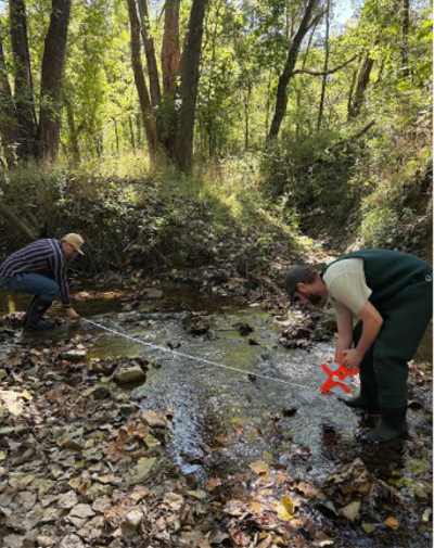
By: Eva Morie
On Thursday, October 9th, NRES ambassadors Brodie Carr and Eva Morie, along with NRES sophomore Les Brown, attended the Hoosier Riverwatch Training hosted at the Owen County Soil and Water Conservation District office. This program, operated under the Indiana Department of Environmental Management (IDEM), was recommended to us by a guest speaker from the Big Pine Creek Watershed, who mentioned it was a great opportunity to volunteer and conduct water testing. The Hoosier Riverwatch program is a volunteer network that engages Indiana residents in becoming stewards of Indiana’s water resources. The program offers a free, hands-on stream monitoring training workshop where participants can obtain certification to receive equipment, monitor Indiana’s streams, and upload data to an online database. Through this volunteer network, we can provide public data on the quality of Indiana’s wadable rivers and streams.
The eight-hour workshop started indoors, where we received a training manual, multiple example data sheets, and a complimentary poster. In the classroom, we learned the fundamentals of water quality monitoring, from safety to watershed identification. We followed along with the training manual, identifying our hydrologic unit area codes, recognizing healthy stream indicators, and reviewing in-field data collection procedures. We learned how to input our data into the database, then sat outside for lunch before performing the fieldwork.
The fieldwork was very similar to the techniques learned in our required Environmental Field Skills class (NRES 338). We headed over to Elliston Creek, a tributary of the White River, to practice our data collection. We started by assessing the habitat using a Citizens Qualitative Habitat Evaluation Index (CQHEI), which evaluates the substrate, fish cover, stream shape (along with human alterations), the riparian area and signs of erosion, the depth and velocity, and the presence of riffles and runs. These variables are scored and totaled to produce an overall rating. Then we calculated the stream flow (discharge) and added this data to a data sheet. This was calculated by averaging the width, depth, and velocity and multiplying these by a coefficient to find the rate of the stream flow.
Next, we assessed the stream’s chemistry and recorded the variables on the Chemical Monitoring Data Sheet. We took three samples for each variable, including temperature, dissolved oxygen, pH, nutrients, and turbidity. These were averaged to create a Water Quality Index (WQI), which rates the stream from excellent to very bad. For our last test, we looked at the macroinvertebrates in the stream. The macroinvertebrates were collected, identified, and recorded on a Biological Monitoring Data Sheet. The taxa represented are grouped by their pollution tolerance, from intolerant to very tolerant. The Pollution Tolerance Index (PTI) was collected and rated from excellent to poor. This was by far our favorite part, we found crayfish, snails, mayfly nymphs, and caddisfly larvae, to name just a few!
Overall, this experience provided us with strategies for data collection and enables us to volunteer and collect data at any stream in Indiana with the Riverwatch Equipment Kits. The program allows us to practice data collection protocols, enhancing our skill set for future environmental positions. We also can contribute to public access data on the Hoosier Riverwatch database. This is an invaluable resource for communities to identify possible pollution sources and track environmental changes to make informed decisions for conservation and land-use planning. We highly recommend this volunteer program to any interested parties and are grateful for the experience and opportunities that come along with the certification!
 Originally posted 11/3/2025
By: Sara Zukowsky
Applying to and figuring out if the EEE 4&1 Program is right for you can be very stressful, but it does not have to be with help throughout the process! I am currently enrolled in the MSEEE 4&1 Program, with a bachelors in NRES, and a masters in EEE. I am in my senior year, meaning I can take up to 12 credits for the program this year, and the remaining next year, as a full time graduate student. It is a really great option if you are considering consulting in your future career. Personally, I want to work on consulting on renewable energy sources, making it a good program for me, with common environmental engineering issues arising.
In the 4&1 program, during your last undergraduate year, you are able to take up to 12 credits and apply them to the program. You will take a total of 30 credits to complete the masters, so you’ll be left with 18 during the fifth year where you complete your masters. Of those 30 credits, all of them have to be 500-level or above. However, only 9 credits are required to be EEE. Others can include any other form of engineering, and there are pre-approved courses from: FNR, STAT, AGEC, AGRY, EAPS, and more! You can also email the representative and ask if a course can be applied if it is something you think will add to your experience. Once you get in, you will get access to a list of pre-approved courses. So far, I am currently in FNR 58600, Urban Ecology, and CE 59700, Disasters & Emergencies. I absolutely love both of these classes, and they are some of the most fun courses I have taken at Purdue.
If you’ve decided this sounds right to you, great! To apply, you need a 3.00 GPA, two essays, a resume, your transcript, and three letters of recommendation. For your GPA, I encourage you to apply even if you do not meet that requirement, as other students have gotten in with slightly below that requirement. For your essays, there are the Academic Statement of Purpose and a Personal History Statement. The Academic Statement of Purpose covers your career goals, interests, experiences, and skills and is expected to be no more than two pages long. The Personal History Statement covers your background and life experiences. I encourage utilizing the Purdue writing lab when writing these. They can help you at any stage of writing these statements, but I found them most helpful with editing my statements to make them sound more professional.
For your resume, they accept either a resume or a CV. I chose to submit a CV so I could discuss relevant coursework I had taken, specifically, the prior EEE courses I had taken, which included EEE 35500, EEE 23000, and EEE 35000, all for the EEE minor. It also included ENGL 30600, Introduction to Professional Writing, because of its importance in graduate school, NRES 38800, Environmental Field Skills, to show skills I have learned, and finally, my Principles of GIS class, that showed I know how to use GIS. I got my CV reviewed by the Center for Career Opportunities (CCO). To make that appointment, go to Boiler Connect, select a Career/Pre-Professional Advising Appointment, then scroll to CCO/Quick Chat, and finally choose theResume/ CV Review option. I definitely encourage you to utilize the CCO and Purdue Writing Lab, because applying to grad school is a new experience, and the advice you get is from people who have experience with these documents, when you may not.
Then, you need your Purdue transcript, and finally, three letters of recommendation. I encourage you to think about what the writers of the letter of recommendation can add to your application. I got my letters from my AGEC 40600 professor, my ENGL 39200 professor, and my current boss at the time. From my AGEC professor, I was in his office hours at least once a week to help clarify on the things I didn’t understand and help with homeworks or before his exams. I asked him to reflect on my dedication through the course by my engagement with the material in his letter of recommendation to emphasize my work ethic. For my ENGL professor, I spoke in every class and always answered her questions, so I asked her to discuss my engagement and dedication to materials in her letter. I asked my boss to detail my work ethic and attention to detail while working for her, to enhance my application in that way.
Overall, this is an excellent program that allows you to get a Master of Science in Environmental and Ecological Engineering, if that’s something you’re interested in. Applying to grad school can be difficult, but hopefully this blog helps the process along!
Originally posted 11/10/2025
By: Aaliyah Carlisle
This past summer, I was able to take the opportunity to travel to Kenya for a 2-week-long study abroad through Purdue. Now I know what you may be thinking: why go all the way to Kenya to look at farming systems when we have so many in the United States? And my answer to that is simply, why not? Why not see what the world has to offer and what solutions they have in continuing to fuel the world?
There were amazing sustainability practices in many of the farms we visited. As a group, we mostly stayed close to Nairobi, the capital of Kenya. Every day, we would drive to visit a different farm or business. One of the most memorable farms we went to was actually part of another college, Miramar International College. There, they had a completely closed system for Black Soldier Fly production. They would let the maggots (baby flies) decompose food scraps, and there they would grow into full adults. Then the adults would be used to make protein after they had laid eggs. This was something I’d never seen before, and it was fascinating to see how a system could be utilized so well.
 One thing that’s important to note is that Kenya has less than 16% of its land that can be farmed. So when it comes to production, being sustainable is vital. Many places we visited while here had large greenhouse production as well. While touring the greenhouse, you could see how well the spaces were being utilized. Green peppers and tomato vines were growing vertically on strings in order to have more room to grow. It was amazing to see, and the smells and tastes of the vegetables and fruits were delicious. Not to mention, the size of the vegetables were huge. With the greenhouse production, no pesticides or herbicides were used, so we were able to eat things straight off the vine!

Now, one of the last places we visited didn’t have anything to do with farming, but it had
everything to do with sustainability. It was a company called Ocean Soles. At this company, they turn old soles of flip flops that are found on beaches and waterways into works of art. We were able to walk through their workshop to see how much work is going into transforming old shoe soles into things like large elephant statues and even small turtles. It was inspiring to learn how things that are thought of as waste can still be valuable.
 Originally posted 11/13/25
By: Elina Gorenstein
Life as an NRES student can be stressful. It’s important to maintain healthy stress relieving habits like getting good sleep, proper nutrition, and moving your body. For me, one of the easiest ways to get moving is to go birdwatching! I’ve been birding since I was a kid, but I’ve honed in on some good places around campus to spot our feathery friends. Most of these places are close to residential campus, but some are farther than others.
When you’re preparing to go birdwatching, don’t feel like you need a lot of fancy equipment. You don’t necessarily need a fancy camera or wildly expensive hiking boots. The beautiful thing about birding is that it’s really accessible to beginners. All you really need is yourself, a comfortable pair of shoes, and your phone with an identification app downloaded (or a paper field guide). I like Merlin Bird ID from the lovely folks at the Cornell Lab of Ornithology as well as iNaturalist. Merlin is neat because it’s bird-specific and is constantly updated with new birds from around the world, and it keeps a list of all of your identified birds. iNaturalist is a cool app that helps researchers across the country collect real-time ecological data. You can take a photo of a species (not just birds!) and iNaturalist users and their database will help identify your findings. You do need an account to use both of these apps. If you’d rather go old-school, take a field guide. I like Birds of Indiana by Stan Tekiela because it fits in my jacket pocket.
Next, don’t be glued to your phone – look up! As you walk towards your birding destination, keep your eyes peeled for birds along the way. This is also a good time to lock in the focus on your binoculars: make sure they’re set for the bridge of your nose. Consider the timing of your visit, too: birds are most active at dawn and dusk.
If you’re walking from campus, your best birding spots will be Horticulture Park and Celery Bog Nature Area. For Horticulture Park, walk down Third Street past Third and West and cross the street. Go over the bridge and you’re in! Horticulture Park has a lot of habitats that bring many kinds of birds to the area. In the prairie area, you can look for American Goldfinches and other prairie-dwelling birds. In the cultivated gardens, I often see robins, Northern Cardinals, and blue jays. Wandering into the forest, it can be a little harder to spot birds, but pay attention to the critters running around on the forest floor – I see many kinds of squirrels, chipmunks, and deer if I get lucky. In the spring, Horticulture Park has beautiful blooms of Virginia Bluebells. Overall, I’d rate Horticulture Park a 8/10 for location, and a 6.5/10 for birdwatching.
Celery Bog Nature Area is a bit farther from campus, but in my opinion, is well-worth the walk. If you’re walking from campus, walk towards the soccer fields on McCormick Road. At the 4-way stop, cross the street onto Cherry Lane and follow the path to the Student Farm. In between the Student Farm and the Turfgrass Research Center, there’s a bike path that leads almost exactly to the Bog – cross Lindberg Road and you’ve entered the park’s property. If you’re more interested in seeing migratory species, especially waterfowl, head down the path towards the water. There’s a path going around the marsh, with observation platforms and viewpoints along the way. Be patient – waterfowl are best seen around sunrise and sunset. Find a nice spot to settle down and watch the water. You may also see other marsh animals, like muskrats and beavers, as well as foxes, raccoons, deer, and more. I saw a mink once last summer but haven’t seen one since! Once your waterfowl spotting is done, head to the nature center to check out their feeders. There are often many birds at the feeders, and the diversity of the species is relaxing to see. After that, wander over to the prairie area and see if anybody’s flitting about. I’d rate Celery Bog a 5/10 for location just because it’s so far from campus but a 10/10 for birdwatching.
If you’ve got a car, Jasper-Pulaski Wildlife Area is a must-see for migratory bird enjoyers. Every winter, tens of thousands of sandhill cranes descend on Indiana. I recommend going right at sunset so you can watch all the birds fly in for the night. The cranes are an absolute wonder to see and I look forward to them every year! Jasper-Pulaski is about 50 minutes off campus, so definitely not a feasible walk, but if you can find a buddy with a car! I rate it a 1/10 for location (and proximity to campus) but an absolute 11/10 for birdwatching. It’s always a fun treat to see deer and coyotes in the same field as the cranes.
When you see a bird, you can admire it through your binoculars or take a photo to identify it with. Generally, I try to take photos in the moment and identify when I get back home. Enjoy watching it go about its day and try not to spook it by making noise. I love to watch their wings as they move through the air – it’s so mesmerizing! Once you get home, don’t forget to identify your birds. Keeping track of the birds you’ve sighted is a great way to see what species are most common to our region, but it’s also meditative to go through the steps of identifying a bird. It feels like a puzzle that I get to solve! My identification strategy is to sort by native and migratory range, by color, then by size. By this point, if I don’t have a rough identification, I will turn to Merlin’s ID function. If Merlin’s confused, the last trick I’ll pull out of my hat is searching by image, which usually gets me a final ID.
I find birding to be incredibly therapeutic, and I’ve found myself doing it more as the semester progresses. I hope you will enjoy it as much as I do. Again, life as a student is stressful, but coping mechanisms and beloved hobbies will make it easier to handle. I hope you give birdwatching a try: it’s not just for old ladies!
Originally posted 12/1/25
By: Hanna Dykema
This summer, I had the privilege of interning at Marshall Associates in Grand Rapids, Michigan! Marshall Associates is an environmental services firm whose main focus is to provide environmental due diligence for property buyers, primarily in the form of Phase I ESAs. Environmental due diligence is the process of assessing contamination and risk on a property, which buyers need in order to make informed decisions and avoid liability. The purpose of a Phase I ESA is to research the current and historic uses of a property and determine whether or not there is a risk of environmental contamination. Our job was to research these properties, determine whether or not they had Recognized Environmental Concerns (RECs), and write our findings into a standardized report.
From being assigned a site to compressing the final deliverable, there are several steps within the Phase I report-writing process. First, I had to research the property and gather as much information as possible on it. This involved retrieving historical information such as aerial photographs, topographic maps, and Sanborn maps. I would also make Freedom of Information Act requests to the county health department and fire departments to access well/septic tank and building/demolition records. We would also collect assessing records, a title commitment, and a survey of the property.
In addition to compiling all of these documents, another part of the research process involved a site reconnaissance where we walked around the property to assess its current state. We would take pictures of every room, each side of the building, and notable features on the property. A few of the features we kept an eye on included chemical storage, health of vegetation, staining, drainage features, and pipes. I learned a lot from my supervisor during these site inspections because of the attention-to-detail and knowledge required to accurately assess a location. This was my favorite part of the process because each site was very unique and presented a new learning opportunity! Some of the interesting locations I walked through included a manufacturing plant, porta potty/carnival ride company, old film school, and a sensory deprivation tank spa.

Once we walked the property and received all the documents needed, we would conduct a research complete meeting where we looked at every document/picture and determined whether or not the property had a REC. After reaching a conclusion, I would begin writing the report by following a standardized template and inputting all the information related to the property. It would then be reviewed several times and edited so that it was ready for the client. This was a big learning curve for me because the wording in each report had to be very specific and accurate. I would get a lot of edits on my first few reports, but that was the best way to learn!
This experience was extremely formative to my professional development. As an intern, I was lucky enough to be tasked with the same level of work as an Environmental Professional, which meant researching and writing reports on my own. While my supervisors made sure to teach me each step of the process, this responsibility taught me to stay organized, manage my time, and ask lots of questions. It was incredibly valuable for me to learn about this aspect of the environmental consulting world and discover what I liked/disliked about the job. For example, I really enjoyed working with the routine on each site yet experiencing something new every day, but the amount of travel required was a bit of a struggle at times. I really enjoyed the group of people I worked with as well and am grateful for the experience!
 Originally posted 12/2/25

By: Brooke Lederman
My junior year, I had to take a class that many NRES students are very familiar with or at least will be: Natural Resource and Environmental Economics. While suffering through this class, I got to know a girl a year older than me. We had an offhand conversation one day about her needing to look for an undergrad to fill her position in Purdue’s Agriculture department, in the office of International Programs, once she graduated. Since she had seen me in the office for an unrelated meeting at one point, she asked if I would be willing to fill the position. Although I didn’t have a large interest in agriculture at the time, and I had never heard of the International Programs office, I needed money and accepted the role. What I didn’t realize at the time was that the semester position was a pre-cursor to a larger summer internship.
This leads me to this past summer, when I had the pleasure of working with Purdue’s International Programs in Agriculture department (IPIA). While the job included things like cleaning up the departmental website, organizing files, and helping out with miscellaneous projects, I spent a majority of my time assisting with the planning and operation of the Mandela Washington Fellowship for Young African Leaders. The Mandela Washington Fellowship is a U.S. government sponsored program where 500 African entrepreneurs and leaders chosen from an applicant pool of around 25,000 are divided among universities across the country where they are hosted for six weeks. During this time, they attend trainings and workshops, tour businesses in their related fields, enjoy cultural experiences, etc. They all also work on their own personal projects, pitching their business ideas to the network they create while in the U.S., to end up presenting at the end of the program at the summit in Washington D.C.
I had the opportunity to get to know each of the African “fellows” very well throughout their time at Purdue. While driving them to their different commitments, attending workshops with them, helping ensure they all had the materials they needed, and helping to plan various outings, I became very familiar with their business ideas, motivations, and backgrounds. Many of them wanted to start companies that would in some way benefit smallholder farmers in their home countries. They were worried about things like sustainable and accessible irrigation systems, plant propagation in arid environments, and soil conservation. These were all concepts I had learned about throughout my time in the NRES major, but I had never really seen myself applying them in my career. Spending time surrounded by the fellows and their ideas fostered a new passion in me for sustainable agriculture. This experience was eye-opening and changed the trajectory of my college career and life post-grad, even as a rising senior at the time.

Through this internship with IPIA, I met multiple returned volunteers from the United States Peace Corps. For those who aren’t familiar, the Peace Corps is a volunteer organization where you work for two years in a country that requests help for projects in a variety of different sectors including economic development, education, health, youth development, environment and agriculture. With the help of the connections I made through this internship, I began looking at Peace Corps opportunities for myself in the environmental and agriculture sectors. As of now, I am about to wrap up the application process to a coastal restoration and conservation project that would take place in the Philippines in 2026.
I also ended up partnering with one of the fellows from Zambia to apply for a Reciprocal Exchange grant that would allow us to host soil conservation and sustainable irrigation workshops for smallholder farmers in his home country. We find out if we won the grant money in December of this year.

Without this internship in an office I had never heard of, I would not have found the support system that has helped me get to where I am now. I would never have found out that I do have an interest in sustainable agriculture and gone outside of my comfort zone to work on a project that I really care about. This experience taught me how important it is to take advantage of the opportunities that are presented to you, even when they don’t seem perfectly in line with the things you have done up to that point. It is easy to feel like there is one track you should follow or that everyone seems to know exactly what direction they’re going when you’re in college, especially one filled with such driven students as Purdue. It is so important to keep an open mind and not limit yourself to only experiences you have heard of other people in your field having. You never know who, what, or where every new experience could lead you to.
Originally posted 12/4/25
By: Grace McRoberts
As environmentalists, it is common for a love of exploring the outdoors to be associated with us. Hiking, rock climbing, and everything in between. I personally have always been a fanatic of a good workout, whether that be in the form of a run, or a lazy backstroke. I was worried upon coming to college, that these activities would cease being a part of my daily routine. Venturing from a warm climate, I figured I would be sat inside for the majority of winter, learning to knit to avoid going stir crazy. I was quite wrong.


My first semester I decided to continue my love for swim and join the swim club! Three days a week, and a very reasonable fee, I was quickly hooked. Also nervous to make friends, the freshman briskly bonded over the fast-moving paced workouts used to keep from freezing in the Olympic sized pool. As second semester came along, I wanted to expand my horizons and attempt to push outside of my comfort zone and learn how to lift (properly). One of my closest friends decided to take it upon herself to teach me. The Purdue corec is monumental, and with multiple levels, I was intimidated. Finding a workout buddy eased some of that anxiety surrounding all the equipment and their unknown purposes, and overtime, became a fun environment. I learned how to rock climb, joined a few intramural teams (very fun, highly recommend), discovered the multiple saunas and their benefits, dance fitness on Wednesdays, and much more. This continued to be a wonderful outlet for young Grace.

Second semester sophomore year came along, and I got the calling to try something new again, I landed on the Purdue crew team. I had never rowed a day in my life, and it showed the first few months. Although considered a club, the team was sectioned into four groups (novice/ varsity, men/woman), with practices held six times a week. This become a lifestyle, and I haven’t looked back since. The teammates slowly turned into friends, and as the practices turned more and more social, I fell more and more in love. Winter seasons were spent inside the boathouse, working out as a whole team, and racing season was spent cheering on my partners in speed. As there are many stories similar to mine about different club sports, I couldn’t recommend them enough. I had to try a few to find the one I loved, but each allowed me to stay active, and meet some wonderful Purdue attendees.
 I want to conclude by saying there are other ways to stay active, find a friend with a car, and in the fall and spring, there are plenty of hikes all around Indiana, close to Purdue. I never ventured to the golf courses, but they are well maintained and open to students. I’m sure I am forgetting some other ways, but moral of the blog is don’t be afraid to try new things!
 Originally posted 12/9/25
By: Katelyn Bottando . . . A totally unbiased blog post by yours truly (The ESC President)


When I was looking to join some clubs my freshman year, I was completely unsure where to even start. I went to a bunch of callouts, but nothing seemed to really stick. Between work and school, I didn’t feel like I had time to do the things I wanted to do. I had to sit down and think about how I wanted to spend my time in college and (maybe) how I could organize my weeks and actually do something engaging and educational. It started off with something small- a rock painting event- and spiraled into something much bigger: community engagement, inspiring hikes, and learning how to use a handsaw (whaaaaat)!
Back in the ye old times, I did not know about the amazing hiking spots around campus and how easy it was to immerse myself in nature. I also didn’t know how to identify trees. And, quietly honestly, I didn’t know much about plants. If you want to learn these things, I have attached some links at the end for you to explore. However, if you want to learn some in-person, on-the-field tactics, then this club might be a good option for you.
Let’s get to the good stuff. In this club, you will meet other like-minded individuals that like to go out in nature and maybe also paint rocks. You will go out and explore (on and off campus, free transportation provided) hiking trails throughout Tippecanoe County and experience field work as done in the daily lives of environmental scientists. You will probably make friends. You will likely get a free plant.
Thanks to a few friends and some fun events, I am now serving as the President of the Environmental Science Club, and you can too! I’ll be out of here in the spring and we need some new club officers. So, if you’re feeling up to it, grab a pair of good hiking shoes and come along with us!
Originally posted 12/13/25
Past Blogs
By: Kendall Daniels
What to do after graduation can be an intimidating thought. Luckily for us NRES students, we have our options. According to the U.S. Department of Labor, environmental scientists and specialists employment is projected to grow 5 percent between 2021 to 2031, a rate consistent with the average for all occupations. Under this umbrella of environmental scientists and specialists, professional, scientific, and technical services are predicted to grow 10.1%, a rate much faster than average. As of May 2021, the median annual pay for environmental scientists and specialists was $76,530, or $36.79 an hour, above the median annual pay for all US jobs. With the typical entry-level education for this field being a bachelor’s degree, here are some positions you may want to consider upon graduating from NRES.
Environmental Consultant
Job Description: Consultants ensure the client is in compliance with environmental regulations. They may do field or desk work as they evaluate and provide solutions for environmental impacts.
Average Salary: $67, 095
Education: A bachelor’s degree is typically required, though some firms may require environmental consultants to have a Master’s in environmental science.
Where: consultants may work in either the public or private sector, i.e., AECOM, TRC
Park Ranger
Job Description: Rangers preserve outdoor areas, typically in national and state parks. They ensure visitors adhere to rules related to safety and may provide park information and environmental education to visitors.
Average Salary: $40,988
Education: bachelor’s degree and employer specific training, often a CPR and CPRP certification
Where: public, i.e., National Park Service
Geographic Information Systems (GIS) Specialist
Job Description: These specialists use GIS software and data to create maps and graphs that analyze and present geographic or spatial data.
Average Salary: $60,614
Education: bachelor’s degree, though some positions may require a more specialized undergraduate degree in geography, computer science, etc. Knowing programming languages like Python and ArcObjects is helpful. You can become a Certified GIS Professional (GISP) through the GIS Certification Institute.
Where: public, private, and nonprofit, i.e., Schneider Geospatial, local counties
Environmental Health and Safety Officer
Job Description: Environmental health and safety officers are responsible for ensuring compliance with environmental safety laws. They work to protect the environment from business malpractice and employees from environmental hazards.
Average Salary: $97,164
Education: bachelor’s degree, optional certification in Hazardous Materials Management
Where: public and private, they may work for a single organization or on a contract basis to multiple companies, i.e., Amazon, EPA
Environmental Planner
Job Description: Environmental planners assess the impacts of construction projects on the environment. They also conduct environmental permitting, write reports, and mitigate environmental impacts from development projects.
Average Salary: $86,919
Education: bachelor’s degree, GIS knowledge, AICP CEP certification
Where: public and private, often for local government or consulting companies, i.e., HNTB, local municipality
Natural Resource Technician
Job Description: Technicians maintain, improve, and preserve wildlife habitats. They may survey vegetation, monitor air and water quality, and work alongside conservation scientists.
Average Salary: $47,829
Education: bachelor’s degree, driver’s license
Where: public i.e., Soil and Water Conservation districts, parksConservation Scientist
Job Description: Conservation scientists manage, improve, and protect natural resources to maximize their use while minimizing environmental damage. They may conduct soil surveys, develop plans to eliminate soil erosion or to protect rangelands, and instruct farmers in the best ways to conserve soil and water.
Average Salary: $69,810
Education: bachelor’s at minimum, but a master’s is necessary for research
Where: public and private, i.e., NRCS, August Mack Environmental
Sustainability Specialist
Job Description: Sustainability specialists work with clients to design and implement energy and resource conservation practices to reduce said clients’ impact on the environment.
Average Salary: $58,491
Education: bachelor’s degree
Where: predominantly private but also public, i.e., electric companies, cities, ALDI
Environmental Compliance Specialist
Job Description: Environmental compliance specialists monitor and investigate complaints of pollution control law violations. They may research hazardous materials that possibly threaten the environment and manage special waste approvals.
Average Salary: $79,515
Education: bachelor’s degree
Where: public or private, i.e., Subaru, Coastal Ecology Group
Energy Manager
Job Description: Energy managers analyze energy use to develop programs that promote energy efficiency. They work to reduce energy costs from consumption and may retrofit buildings.
Average Salary: $89,166
Education: bachelor’s degree, though some positions may require an engineering degree. Most require a Certified Energy Manager (CEM) credential.
Where: predominantly private but also public, i.e., Pfizer, state government
Originally posted 9/21/23
By: Abigail Seybert
Many Natural Resources and Environmental Science students dream of working for the Environmental Protection Agency, Forest Service, or the National Parks Service. The one thing these agencies all share is that they are on a federal level. As a past intern for the EPA and a seasonal crew member for a federal government program, the application process can be quite confusing. This blog post will hopefully clear that up and help you apply to federal positions.
The first thing to note about federal jobs is that they are all located on a single site: USA Jobs. This website contains all job announcements at every experience level. Before diving into this, though, I’ll go over the resume builder located on USA jobs.
For people just beginning with the USA jobs system, the website provides a resume builder with your account when you sign up. Here, you essentially plug in all of your information, experience, and education to be put in a resume. It is important to note that federal job applications typically require more information, so the resume builder ensures you are entering all necessary information. Once I started using the federal resume builder to apply to jobs instead of a personal one that I made, I received more interviews and offers. Here’s a helpful link if you want more information: Resume Builder.
Now that the resume is complete, let’s dive into the pay scale. This is based on a GS level, with higher numbers corresponding with higher pay and more experience.
Beginning at the freshmen college level:
GS-3: Students who have started college but have not yet completed two years of school will be at this level.
GS-4: Students who have completed at least two years of college but have not yet graduated will be here.
GS-5: Recent graduates who have their bachelor’s degree with little to no experience will be at this level. One thing to note is that this is the starting level for people who did not join an honors society or have above a 3.0 GPA.
GS-7: Recent graduates who have their bachelor’s and either joined an honor’s society or have above a 3.0 GPA will qualify to apply to jobs at this level. This is great since it will bring you up two steps from the GS-5 level, which means higher pay.
Depending on which GS level you fall under, those are the jobs you should apply for. The federal government is strict with requirements, so making sure you meet the education requirements/work experience in the job description is important. Additionally, with more experience and education, the GS level will continue to increase.
One last thing to mention is that the window for jobs or internships tends to be pretty short. Some of the positions are only open for two weeks at a time, so checking the website often is key to finding positions. The best method for finding jobs you qualify for will be to use the filters. Personally, I search by agency (Forest Service, EPA, NPS, etc.) and then filter by my GS level. That way, I can easily see what jobs are available to me. If you can’t find anything you’re interested in, make sure to check back in a few weeks to see if more jobs were posted!
Now you can apply to federal jobs with more knowledge and preparation! I had a great experience with the EPA where I worked as an Environmental Protection intern at the GS-4 level in Anchorage, Alaska, so I highly recommend seeing what federal jobs are available! Feel free to reach out with any questions!
Originally posted 1/10/24
By Grace Collins
Last spring semester, I had the wonderful opportunity to take part in a short-term study abroad to Costa Rica. Having never been out of the country before, this experience was nothing short of amazing. The program was focused on Agricultural, Environmental, and Community Sustainability, and I had a chance to witness the country’s agriculture and ecotourism industries and how as a nation they are prioritizing the conservation of their natural environments. Here are some of the highlights of the trip.
CoopeSarapiquí
During my trip, I visited a coffee farm called CoopeSarapiquí, where we received a tour (Mi Cafecito Tour) of the land/facilities and learned about their organic growing practices. CoopeSarapiquí is a Fair-Trade Co-op that integrates tourism and farming to create employment for the community as well as give local farmers and artisans a market to sell their products. At CoopeSarapiquí, they offer a meal experience at an on-site restaurant (I ordered the entire tilapia fish).


Orginially posted 4/28/25
By Grace McRoberts
Studying abroad can often feel like a far-off dream, especially when you first think about all the steps involved in making it happen. From acquiring a passport and applying for a visa to booking flights and figuring out the complexities of class credit transfers, the process can seem overwhelming. However, having gone through the experience twice, I can confidently say that it’s not nearly as intimidating as it seems at first glance.

2. Understanding the Application Process
Once you’ve narrowed down your country and program, it’s time to dive into the application process. This can seem like a lot of paperwork, but the key is to stay organized and start early.
- Application Deadlines: Be sure to check deadlines for your program of choice and give yourself plenty of time to gather required documents. These may include transcripts, letters of recommendation, and sometimes a personal statement or essay (the College of Agriculture does require this).
- Visa and Immigration: Depending on where you’re studying, you’ll likely need a student visa. This typically involves submitting your acceptance letter, proof of financial support, passport-sized photos, and other documents. Start this process well in advance, as visas can take weeks or even months to process—especially for countries with stricter requirements.
3. Class Credit Transfers and Academic Planning
One of the most daunting aspects of studying abroad is ensuring that your courses will count toward your degree at home. This is where class credit transfers come into play.
- Speak with Academic Advisors: Meet with your academic advisor or study abroad coordinator early to discuss your goals. They can help you find courses abroad that fit your degree requirements.
- Research Course Equivalencies: Many universities have established equivalencies for courses taken abroad, but it’s still important to confirm that your planned courses are eligible. Some schools may require syllabi to determine equivalency.
- Plan for Flexibility: The courses you want may not align perfectly with your degree requirements—and that’s okay. Studying abroad can be an opportunity to explore new subjects or broaden your perspective, even if it means taking electives.
4. Preparing for the Practicalities: Travel, Housing, and Finances
Once the academic side is squared away, it’s time to plan for the practical aspects of your experience.
- Flights: Start searching early to secure the best deals. Many students fly into a major hub and then take a smaller flight or train to their final destination. Be mindful of layovers and entry requirements when planning your route.
- Accommodation: Depending on your program, you may stay in dorms, with a host family, or in a private apartment. Make sure you understand the details regarding rent, utilities, and logistics. Also confirm what is provided (e.g., meals, laundry) and what you’ll need to bring.
- Budgeting: Create a detailed budget that accounts for tuition, housing, meals, transportation, travel, and daily expenses. Don’t forget to include emergency funds.
- Health Insurance: Some programs offer health insurance, but be sure it covers everything you need. You may want to purchase additional travel insurance for peace of mind.
5. Embrace the Experience
While preparation can feel overwhelming at times, the experience itself makes it all worthwhile. Studying abroad allows you to experience a new culture, make lifelong friends, and immerse yourself in an academic environment that challenges and inspires you.


By Ryland Barton
“Get involved in as many clubs and organizations as you can.” We’ve all heard this advice when coming to college, and we’ve likely shared it ourselves with prospective or freshman students. I must admit, it is solid advice for those just getting started. When you arrive as a freshman, you’re still figuring out your tastes and interests; exploring as many opportunities as possible during your first two semesters is vital to discovering which clubs, activities, and organizations are the best fit for you.
However, as you begin to narrow down your interests, it’s important to ask yourself why you’re involved in the organizations you’re part of. Do you truly enjoy being in that club or organization, or are you just doing it as a résumé builder? If it’s the latter, consider dropping that activity—and here’s why. As someone in NRES, you need to remember that you are not just an average college student. You chose NRES because you are intrinsically motivated to make the world a better place. Therefore, your mindset throughout your college career—however long it may be—should center on making a positive impact on campus.

But to return to involvement on campus: the amount of effort you put into your clubs matters more than the number of clubs you join. Too many people at Purdue are overstretched and exhausted because of how much they take on. They believe that joining as many organizations and participating in as many activities as possible will make them more successful academically or help them secure internships or full-time jobs. However, they often don’t have the time to invest deeply in any one activity. As a result, they miss the opportunity to make a meaningful impact when they look back on their experiences.
So take my advice: focus on 2–3 clubs or organizations that you genuinely enjoy and where you believe you can make a difference. Ask yourself, “How can I make an impact in this organization?” Does the club need more members? Do its regular activities feel unengaging or lack substance? Would you like to help take the organization in a new direction? These are all valuable questions to consider as you define your role.
Once you’ve identified a goal, create a plan for how you will achieve it and start communicating with the organization’s leaders. Share your ideas, discuss potential improvements, and work collaboratively from there.
Alternatively, if you feel that none of the existing organizations at Purdue align with your interests, don’t worry—you can still make a difference by starting your own initiative. For example, after trying both the Environmental Science Club and the Boiler Green Initiative, I realized that neither was quite the right fit for me, even though both offer great opportunities. This led me to create my own blog, GenZ-Earther, which eventually expanded into a YouTube channel of the same name. This gave me the freedom and flexibility to spread environmental awareness on my own terms and focus on topics I’m most passionate about. Don’t be afraid to experiment and pursue your own ideas.
Picture 2: My channel, GenZ-Earther.

YouTube: https://www.youtube.com/@Gen-ZEarther
By Evie Quehl


Picture 1–2: Some photos of the Smoky Mountains
One reason is that we’re not alone. About 70% of Americans believe climate change is real, and nearly 60% believe it is primarily human-caused. Although a loud minority can make it feel otherwise, there is real support for change. This highlights the importance of collective action—when people come together, their combined efforts can make a meaningful impact.
I also stay optimistic because without it, nothing will change. If we only focus on the negative, we risk becoming inactive. Optimism gives us the motivation to act and align with the reasons we chose this field in the first place. To make a difference, we have to believe that change is possible.
Finally, my greatest source of hope is humanity itself. While humans contribute to climate change, we are also capable of incredible innovation and progress. Technological advancements continue to emerge, and countries around the world are collaborating on solutions. This level of global effort is rare—and it shows that change is possible.
In the end, staying optimistic isn’t always easy. Some days, it may feel impossible. But we can’t stop advocating for the environment. The emotions we feel about this issue matter—what’s important is channeling them into action rather than letting them lead to despair.
What makes NRES students special is our shared commitment to the environment. Lean on that community, support one another, and continue working toward a better future. Real change depends on people like us.