2.Drones Finding Broader Uses
RESOURCES - PUBLICATIONS
The Evolution of Spray Drones, Their Capabilities and Challenges for Pesticide Applications
2. Drones Finding Broader Uses
For the reasons above, drone manufacturers had to make major modifications, including redesigning aircraft, repurposing software, and changing onboard imaging equipment. One can only conclude that the wide acceptance of drones has been a function of these enterprises accomplishing their goal of producing a product with practical uses for the public.
Drones for Recreation
Remotely controlled, fixed-winged model airplanes have been around for decades. Many can fondly remember their parents or grandparents teaching them to fly model planes or attending events where pilots competed against one another for best of class. Newer models have more intuitive controls and more advanced features than the old models.
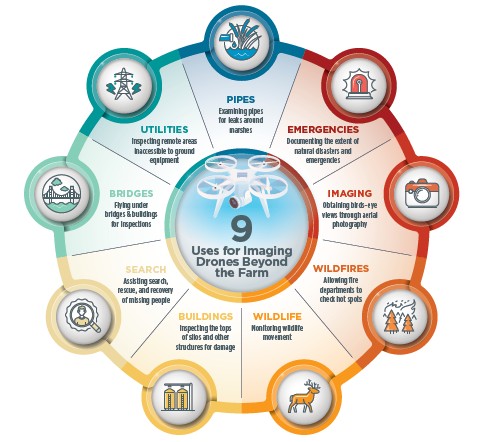
Drones for Imaging
One of the first and most popular applications of drones was to capture aerial images. These images may be traditional photographs or images from specialized cameras, such as thermal (heat) cameras or multispectral (specific light wavelengths) cameras. Some modern drones have the ability to hover and capture a 360-degree view, allowing them to closely inspect areas inaccessible by roads, vehicles, or potentially unsafe locations.
Industries and government agencies have taken advantage of the imaging capability of drones to:
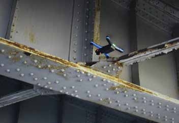
- Fly under or on the sides of bridges and buildings to inspect for cracks and other defects
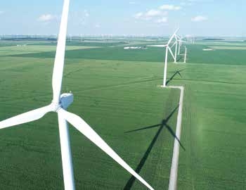
- Inspect utility structures or in areas where ground equipment cannot reach
- Inspect sewer and storm drainage pipes
- Inspect the tops of silos for corrosion or other damage
- Monitor the movement of wildlife
- Examine pipes running through marshes for leaks
- Search for missing people and livestock
- Allow fire departments to determine remaining hot spots that could reignite wildfires or building fires and to assess the overall extent of fires during rescue operations
- Measure and document the impact of natural disasters such as floods, tornadoes, and wildfires
- Describe the extent of emergencies resulting from train derailments, oil spills, landslides, and collapsed roads and bridges
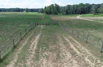 Drones are commonly used to inspect fences
 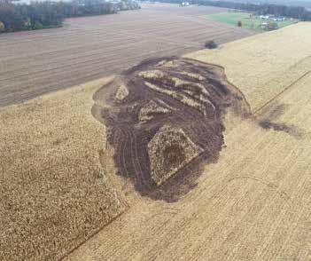 survey fire damage in a field
 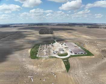 document storm damage
 Drones are also useful for gathering immediate information about property damage. This drone information can direct people to specific areas of interest for more efficient inspections. Considering the dangers of inspecting a collapsed building, road, or bridge, the remote views drones offer can provide invaluable information while substantially reducing the risks to inspectors.
For these reasons, manufacturers worked with camera companies to equip drones with modern sensors to capture high resolution images, record high-definition video, stream these images in real-time to the pilot and crew, and document the images and videos for viewing and processing later.
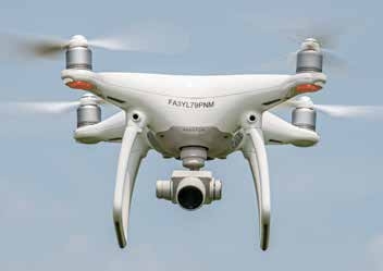 This quadcopter (four rotors) drone hovers near the ground. Its camera can capture photographs and video. The camera is attached to a gimbal that can adjust the viewing angle.
 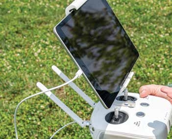 This controller can connect to a tablet, so operators can monitor the drone’s movement. Many controllers have built-in displays.
 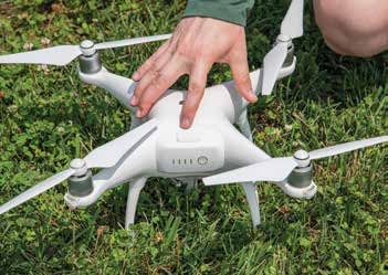 The single battery on this specific drone provides enough power for approximately 25 minutes before it needs to be recharged.
 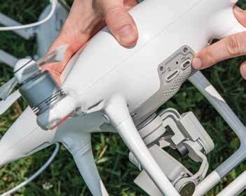 This image shows the drone’s USB port, which is one method for transferring data.
 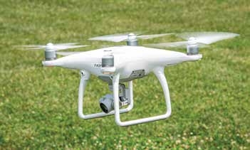 The arrow points to the drone’s obstacle sensor, which notifies the pilot about nearby objects and obstacles in the drone’s path. Many newer drone models have forward, rear, side, top, and bottom obstacle sensors. Many of these features are shared across makes and models of drones in use today.
 In-Field Crop Scouting and Analyzing Field Conditions
Many drone companies thought that by adding better cameras or sensors, farmers would realize the benefits of seeing their farms, fields, or crops from different angles. However, farmers found it difficult to justify the expense of drones. In addition, many farmers may not have grown up with smartphones and related technology, so they may not be comfortable with operating drones with seemingly little return on their investments.
On the other hand, advanced sensors provided decision-making value to consultants, ag retailers, agronomists, and precision ag companies. Drones became another tool that was integrated into the portfolio of services they offered to their clients and customers.
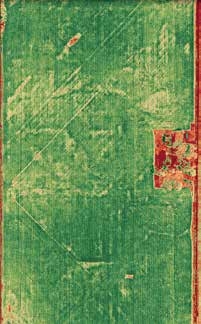
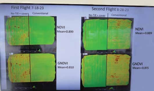
Drones equipped with sensors allow users to monitor crop health over entire fields. Green plants are healthy plants, while hose in red (which do not reflect the green color of chlorophyll) indicate unhealthy plants. However, what is causing these unhealthy plants is unknown — someone must evaluate the area on the ground. Maps like these are detection tools that can help better manage a crop with problems.
Some of the first drones flown in agricultural settings showed field drainage problems and detected crop nutrient deficiencies, crop weather damage, and the severity of pest damage. To some extent, satellite and traditional aircraft-based imagery was used in the past for these applications, but the resolution of these sensors was not capable of capturing subtle differences that drones could detect. Many drones with modern sensors may have a resolution of 0.25 square inches per pixel, depending on the flight height, while a satellite may have a resolution of several square feet per pixel.
A Cloud Full of Data
Drones normally save data to an onboard memory card. Users exchange the memory cards when the cards are full, and it is most common for users to manually transfer data to a computer. Today there are software and service providers that offer automatic data transfer to a cloud-based database or that can even visualize data in real time if an adequate internet connection is available.
Drone manufacturers were asked to equip drones to collect data. Manufacturers responded by equipping drones with built-in analytical capabilities to collect and send millions of data points from their aircraft to a receiver or computer. This data collection also allowed researchers to utilize a complex set of algorithms capable of assessing plant health status using the different wavelength bands the camera captured.
Demand for more sophisticated sensors grew as users learned about these new techniques available to monitor crop health. The new cameras needed to capture high-resolution images that collected many specific light wavelengths associated with crop stress. This led to multiple changes in sensors that are mounted on drones for data collection.
Some of the changes in sensors included:
- Upgrades to onboard RGB cameras. Early digital cameras mounted on drones typically had poor resolution and no zoom features. These cameras could capture general patterns in a field. More advanced drones now have cameras that can capture high-resolution images (such as 48-megapixels) and feature mechanical zoom options. This means the camera can create pictures composed of some 48 million pixels, each pixel containing red, green, and blue color (RGB) wavelengths. These high-definition images can distinguish individual leaves and symptoms on leaves that show diseases, nutrient deficiencies, or insect pressures. Many of the cameras are comparable to professional grade photography equipment.
Drones with sensors can allow users to monitor crop health and progress at multiple periods during the growing season.
- Improvements in sensor resolution and angle of view. The latest cameras have wide-angle views and higher resolution of individual sensors than cameras used on early drones.
- Improvements in multi-light spectral sensors. Integrating multi-spectral sensors that can detect bands of light beyond RGB assisted individuals making better field decisions. These sensors include near-infrared and red edge wavelength bands.
This additional information allows software to compute different indices such as Normalized Difference Vegetation Index (NDVI) or Normalized Difference Red Edge (NDRE), which determines the “greenness” or stress of a crop beyond what can be seen with the naked eye. This spectral information can create color-coded maps where green means “healthy” and yellow and red indicate “stress.” Users can then analyze data through multiple vegetative indices developed by university and industry researchers.
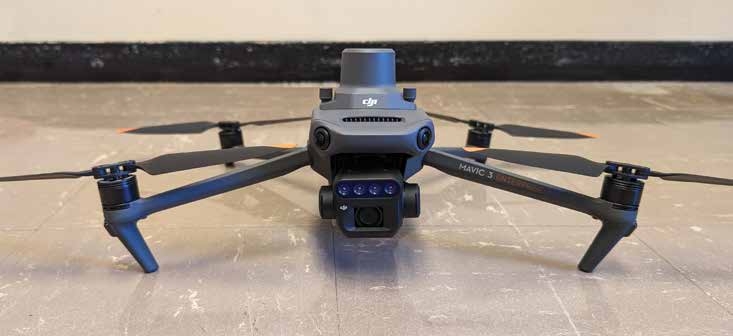
This DJI Mavic 3M has a multispectral camera, which can capture green, red, red edge, and near infrared bands. The larger gray top is the RTK receiver.
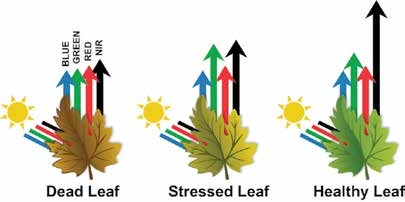
Healthy plants absorb blue light and reflect green light. Image from midopt.com/healthy-crop.
The figure above shows how a healthy leaf reflects a greater amount of near infrared (NIR) wavelength compared to the stressed and dead leaf relative to the red, green, and blue wavelengths. Indices that can exploit the near infrared wavelength have a greater chance of distinguishing between healthy and unhealthy leaves compared to what the naked eye can detect, which only sees the red, green, and blue wavelengths.
- Improvements in thermal and infrared (heat) sensors. Users added thermal and infrared sensors to measure the heat energy emanating from a crop, soil, or other objects. If objects are “hot,” sensors will pick up more thermal energy, while cooler objects emit less heat on the surface. These thermal images convey information about varying levels of soil moisture across the field, detect crop canopy temperature differences, or identify plants that are water- or nutrient-deficient and stressed.
Since healthy plants with adequate water can cool themselves by evapotranspiration, the hot zones in a field may reflect poor crop growth or a reduced plant canopy. In addition to analyzing the crop, operators can use thermal imagery to inspect structures on the farm (such as barns and high tunnels) to ensure they are ventilated or insulated properly.
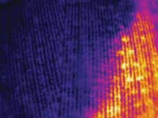
This photo shows the temperature difference between areas that ave and have not been irrigated. The yellow and orange areas indicate much hotter temperatures (and water stress) than the blue and black areas.
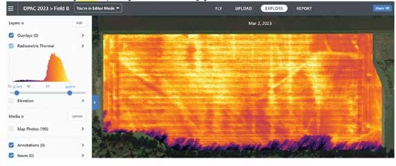
This figure is a thermal image of a field before any crop was planted. The yellow regions show tile lines that have higher soil temperatures from water drainage. Darker colors are more likely to be wetter soils, indicating cooler soils. Thermal imaging can be taken on bare ground to determine elevation for ways to better manage water drainage.
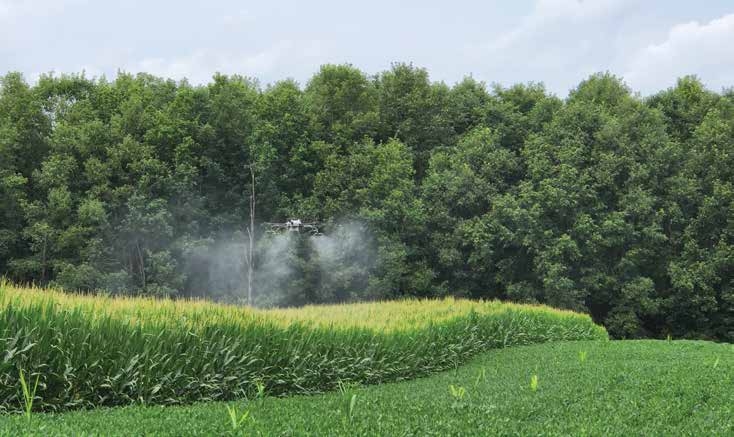
Applying Pesticides and Other Agricultural Inputs with Drone Sprayers
The next logical step in drone evolution in agriculture was to turn them into miniature aircraft equipped with spray systems to apply pesticides. Although some fixed winged drones are equipped to apply pesticides, fertilizers, and seeds, multi-rotor drones seem to be better suited for agricultural applications in fields of varying sizes, shapes, and topographies. For these reasons, much of this publication focuses specifically on rotary-wing drones, which are most common among drone applicators.
The idea of using drones to spray pesticides was put into practice first in Japan in 1997 with the Yamaha RMax drone. The drone looked like a small helicopter powered by an internal combustion engine. This high-powered drone had a single rotor with a diameter of about 10 feet, weighed 207 pounds, and had a spray tank capacity of slightly more than 4 gallons. With a full tank and spraying at 1 gallon per minute, the drone’s tank was empty in about 4 minutes.
Ken Giles at the University of California-Davis was an early pioneer with drones in North America. In 2010, he used the RMax drone that weighed 220 pounds when loaded to apply pesticides in vineyards, then on field crops and orchards. It is likely that Giles was the first to get both federal and state authorization to use drones to apply pesticides.
While this publication focuses specifically on drones applying liquid products, many pilots have found them useful for applying dry materials such as fertilizers and cover crop seeds, too. Most new drone sprayers can be equipped with optional kits to meter and spread these dry products.
DRONE FACT
Many pilots find drones useful for applying dry materials (such as fertilizers and cover crop seeds) as well as pesticides. Users can equip most new drone sprayers with optional kits to meter and spread dry products.