

Satellites and soils: NIFA and AgSEED grants fund remote sensing data collection and machine-learning models to predict soil properties at farm-to-landscape scales
The few inches of soil you pick up on the tip of your shovel are part of a much bigger picture. Made from rocks weathered by winds and water over thousands of years, soils create the foundation of gardens and fields everywhere. Agriculture relies on these ancient assets to provide resources crucial for the world’s food supply.
While soil loss, degradation and contamination threaten farms and ecosystems alike, recent research has indicated that the careful, precise management of soil keeps the precious resource around for longer, increases crop yields and even reduces greenhouse gas emissions. Through the United States Department of Agriculture’s Natural Resources Conservation Service and the Inflation Reduction Act, the U.S. government is funding research that promotes sustainable soil management practices to combat climate change.
They’ve recently invested in Siddhartho Paul, assistant professor of geospatial science in the department of agronomy. Paul’s work creating digital soil maps of agriculture and forest lands in Canada and Sweden recently brought him to Purdue, and a $300K grant from the National Institute of Food and Agriculture - Agriculture and Food Research Initiative (NIFA-AFRI) is kicking off his research in the corn belt.
Digital soil maps display high-resolution, spatial soil information across a farm or landscape, often across whole states or countries. These tools require an abundance of air- or space-borne geospatial—meaning location-specific—data to produce continuous soil information.
 Massive amounts of terrestrial data are now becoming publicly available because of advancements in remote sensing technologies, like satellite imagery, Light Detection and Ranging (LiDAR) systems on planes and specialized cameras on drones. Paul is using this data and connecting it to the complex interactions of parent material, climate, biological processes, topography and time to better understand soil variability and predict soil properties.
“Farmers do not necessarily have the time or resources to extract this geospatial information from different sources and then apply it for their management decisions,” Paul said. “So that's where we come in. My lab is trying to incorporate that information into a prototype tool to show farmers where the optimum locations for soil sampling to assess soil health in their farms are.”
Using indexes of color and wavelengths of light outside of human vision, Paul’s lab turns the pictures from satellites and other technology into statistical representations of soil variability and the effects of different land management practices in the context of specific locations. This gives growers precise information when making management decisions about their field.
To streamline this process and generate useful information for large areas, Paul is also training machine-learning and deep-learning models—subsets of Artificial Intelligence (AI) that analyze patterns in a dataset. One specific model is for soil carbon sequestration—the ability of a soil’s structure and microbiome to take carbon dioxide, a dangerous greenhouse gas, from the atmosphere and store it underground or convert it into material useful for plants.
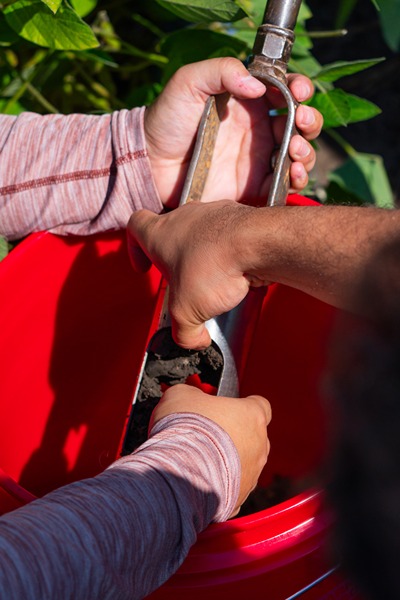
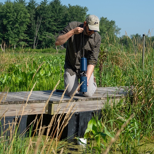
 Siddhartho Paul’s team uses real-time kinematic GPS to collect precise location information (within 10 centimeters) of soil sampling points to correlate with satellite images.
 Using a historical archive of satellite images, these geospatial models will provide answers on how different farming practices impact the fields’ sustainability. Paul said, “We are really interested in soil carbon sequestration to help with climate change. I'm hoping that we should be able to identify which specific management practices are contributing to the accumulation of carbon and crop yield and if it converts into profits because that's one of the bigger questions farmers would be interested in.”
Paul’s lab is collecting data from multiple satellites, across multiple growing seasons and over several years while also compiling information from previous datasets, like the soil types in Web Soil Survey and soil parent material information in Purdue Soil Explorer.
They were also awarded an AgSEED grant by Purdue’s College of Agriculture to analyze the historical dataset from Purdue’s Agronomy Center for Research and Education (ACRE) and calculate how much carbon ACRE’s soils and various management practices have captured over the past decade and how that interacts with crop yield variability. After finishing training these models, Paul plans to adapt their algorithms for the greater Midwest and beyond.
Although new to Purdue, Paul has eagerly joined on initiatives and projects with his colleagues. These collaborations have yielded other interesting ways to use satellite data.
“It's not only the crops, it's also the surrounding landscape that may impact the sequestration potential—trees, hedge boundaries, any perennial grasslands or forest patches within sight,” Paul said. “We think that the fields with more field-edge conservation practices would promote better soil biodiversity, carbon storage and overall ecosystem benefits, but the field’s edge isn’t widely discussed. When we get temporal satellite data, we can attempt to capture the impact of field-edge conservation measures in our soil carbon model.”
Featured Stories
Channing Arndt, research professor in agricultural economics and director of the Global Trade...
Daniel Szymanski and his former postdoctoral scholar Youngwoo Lee, lead author on their paper...
The Costa Rica Rainforest Experience study abroad trip allowed students to experience the wonders...
Trask is writing a new narrative about rats, birds and people as he pursues his doctorate in...
Several Forestry and Natural Resources students, staff and recent alumni have been recognized for...
A plume of contamination spreads underground. A building's foundation weakens. A wetland...
This research is a part of Purdue’s presidential One Health initiative, which involves research at the intersection of human, animal and plant health and well-being.