

Welcome to the Tapawingo Park Virtual Soils Field Trip!
As you read through the narrative, make sure to follow the imbedded links. There are a number of 360° photographs and links to interesting websites to explore. This virtual field trip will work just fine in a browser on a desktop or laptop computer, but you may find that panning and zooming the 360° photos will work even better on the touch screen of your phone or tablet. A laptop with a touch screen should work nicely as well.
Tapawingo Park
So, for starters, let's figure out where we are going. Using the Google Maps app on your mobile device, or Google Maps in a browser, enter "Tapawingo Park, West Lafayette, IN" in the search box. You'll see that Tapawingo Park is right next to the Wabash River and only about a 25 minute walk or <10 minute bike ride from Lilly Hall on campus. Since Tapawingo Park is next to the river, you might guess that it is on the floodplain. That is at least partly correct as you can see from the map below.
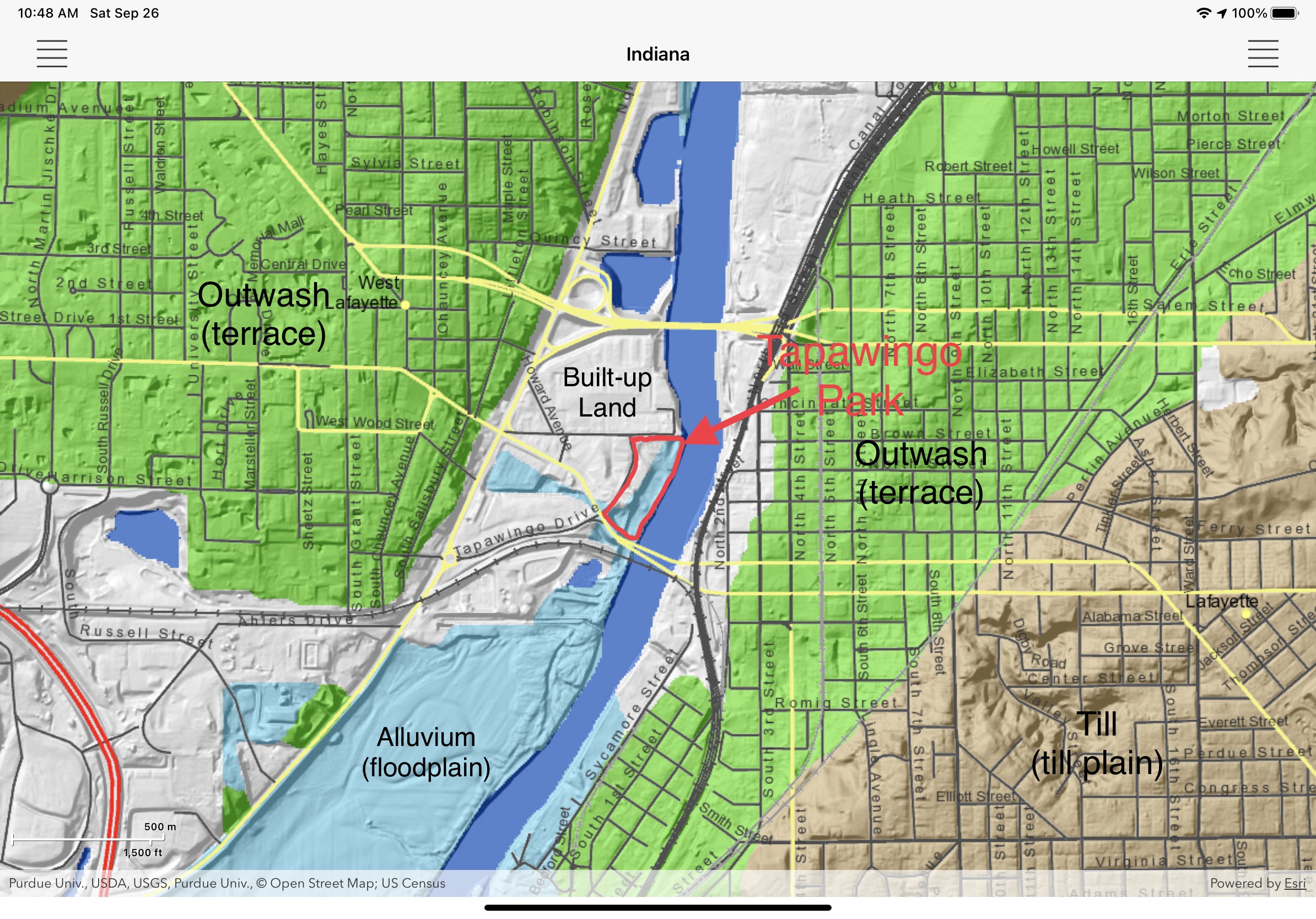
The area from the bottom of State Street Hill to the Wabash River is called the Levee Area. It is on the floodplain, but much of this area has been built up so that it is (hopefully) above the highest flood stage. This built-up land is shown in white on the map. You can see that almost the entire floodplain has been filled in. A man-made levee is a linear embankment built to prevent a river from overflowing its banks and flooding the land behind it. At one time there was such an embankment parallel to the river, but the land behind it has long since been filled in up to the level of the original levee so that a distinct linear levee is no longer visible. The name, however, persists for the area.
The Flood of 1913
The largest flood in Lafayette-West Lafayette occurred in March 1913. You can read about it in this article from the Lafayette Journal and Courier. The first photo you see is the view from Lafayette looking west across the floodplain to West Lafayette. On the high ground just to the left of center is where the Purdue Power Plant would eventually be built. The water almost covered the embankment of the Kankakee, Beaverville and Southern Railroad, which is the railroad that crosses the river just south of Tapawingo Park. The high water mark was about where the McDonald's is at the intersection of South River Road and State St.
A Bird's Eye View
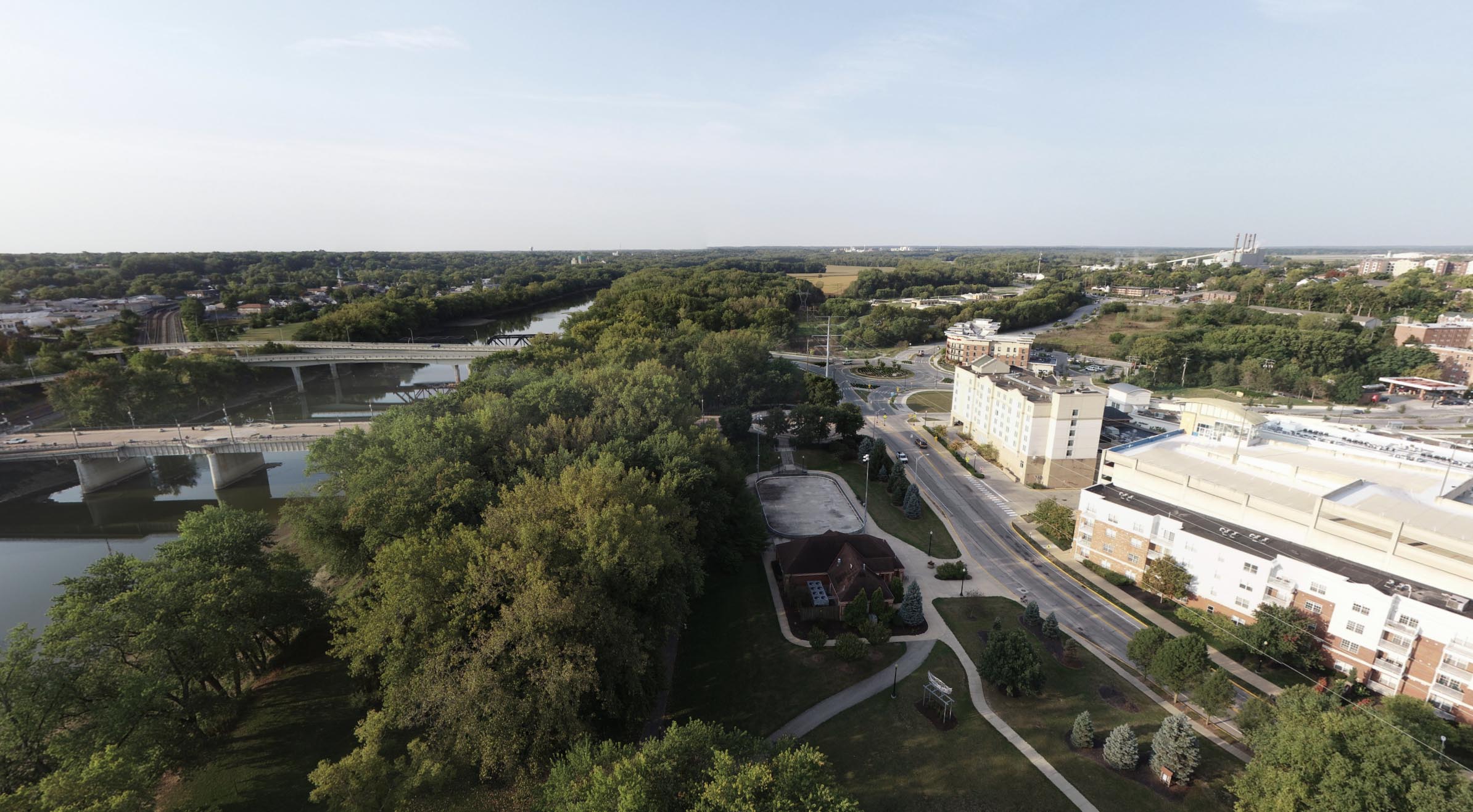
A unique perspective of the area is provided by this 360° image obtained from a UAV (unmanned aerial vehicle) or drone on Tuesday, September 22, 2020. When the image opens, the view is upriver to the north. Pan the image to the east and you'll see downtown Lafayette with the iconic white dome of the Tippecanoe County Courthouse. Downtown Lafayette is on the outwash terrace. It's slightly lower than the part of the terrace that the Purdue campus is on, but still above the flood plain. If you rotate the image to the south, you'll be looking downriver and you can see Tapawingo Park in its entirety. The traffic circle where State Street intersects Tapawingo Drive is clearly visible and you can also see the 4 smokestacks of the Purdue Power Plant. Zoom in, and on the horizon the white buildings you see are the Evonik Corporation Tippecanoe Laboratories, which produces specialty chemicals. Rotate the image to the west, and you are looking across the built up Levee Area to the Village Area with it's high-rise buildings and beyond that, the Purdue Campus. Pretty cool to get a bird's eye view!
Building in a Floodplain
You might wonder why there are so many buildings in the Levee Area even though the area has flooded in the past and could potentially flood in the future. Since about 1985, building in a floodplain has been prohibited in Tippecanoe County. Building construction in the Levee Area, however, began long before that and current land use zoning allows for new construction in the Levee Area, even though new construction is prohibited in most floodplains in Indiana.
Exploring Tapawingo Park
Now back to Tapawingo Park. If you want to see what Tapawingo Park looks like, explore some of the photos available in Google Maps. The park features an ice skating rink, access to the Wabash River, and the Wabash Heritage Trail passes through it.
Referring to the map above, note that about half of the park consists of built-up land parallel to Tapawingo Drive. This is where the ice skating rink and the children's playground is located. Only the half of the park along the river is on undisturbed alluvium on the original floodplain.
Soil Parent Materials in Tapawingo Park
This link will take you to an image taken at Tapawingo Park on Friday, September 25, 2020. It was taken on a sandy area just a few meters from the channel of the Wabash River. (The GPS latitude-longitude is 40.42136, -86.89749, which you can copy to Google Maps to see the exact location.) When the image first opens, you are looking to the southeast across the river to downtown Lafayette where you can see the white dome of the courthouse. Keeping in mind that the river is flowing from the north to the south right here, rotate the map so that you are facing east and the river is in the middle of the screen. The trees to your left are right at the edge of the channel, and if you zoom in a bit, you can see the drop-off down into the channel. The river is quite low, so you would need to walk across part of the riverbed to get to the water. Now rotate the image to the west about 180 degrees so that you can see the parking lot and the shelter with the picnic tables. If you zoom in a bit, you can see that there is a low spot between where you are standing and the parking lot. Now, rotate the image so that you are looking north. The river will be on your right and the low spot towards the parking lot will be on your left. Look down, and you'll see that you are standing on a sandy ridge. This video (there is no audio) illustrates how sandy it really is. It helps to expand the video to full screen to see more detail.
This is clearly in the sand texture class. More specifically, it is medium sand because the particle size range is predominately in the middle of the 2 - 0.05 mm size range for sand. The dropper is adding 10% HCl. Since the sand effervesces (fizzes) vigorously, it indicates that the sand contains much calcium carbonate. Most of the calcium carbonate appears to be in the form of bits of shells from the freshwater snails and mussels that live in the river and surrounding tributaries. A fairly intact shell is visible left of the center. Some of the calcium carbonate is also from the calcareous glacial till that has contributed sediment to the river. Since the sand is calcareous, the pH will be around 7.8 or higher.
The sand here was deposited by water as the river flooded and overflowed its banks. The sand was suspended in the rapidly flowing water in the main channel, but when the river overflowed, the velocity and turbulence of the water decreased. Recall from a previous lab how quickly sand settled out when you did the texture analysis by the hydrometer method. After only 40 seconds, the sand settled out below the bottom of the hydrometer. The same principle applies here. The sand settles out close to the channel of the river, while the silt and clay gets carried by the water to quieter, slack water areas further from the main channel. Often these are at the very edges of the floodplain, but right here those areas have been filled in by human activities. There is, however, a slack water area not far from this sandy area and we'll look at it next. Watch the video to see where we are going. (Sorry about the jitter. It definitely needs some image stabilization!)
We are now in a low, slack water area that has very different soil. Go to this link to look around. As you can see, we are in a wooded area that is about 10 feet (~3 meters) lower than where we were before. When the river floods, the water is not moving very quickly through this area, so finer material settles out here. The soil is very different here as shown by this video.
The soil here is much finer and occurs as clumps of soil called peds. The soil is dry, but the peds can be broken up easily with your fingers. After moistening the soil, its texture by feel was determined to be silt loam. This is very different from the sand we just looked at and illustrates how quickly soils can change in a floodplain depending on where different materials sedimented out. The 10% HCl test shows less effervesce (bubbling) than for the sand, but there is some, so this soil is calcareous with a pH around 7.8 or higher.
The parent material of the soils here on the flood plain is alluvium, material that has been deposited by running water in fairly recent time. You have seen how different the surface soil can be over just a short distance. The same thing occurs with depth. Alluvium is often stratified, meaning it consists of layers or strata of sandy material alternating with layers of silty or clayey material. Ideally, we would have a pit to look at the stratification, but digging a pit in a park is likely to attract more attention than we would like.
Soil Classification
Since new sediment is added to floodplains regularly, sediment builds up more rapidly than soil horizons can form. As a result, soils on floodplains tend to be very young and usually have only an A horizon on top of C material. These young soils with no pedogenic development other than a light colored surface horizon are classified as Entisols. At the suborder level, they are Fluvents, Entisols on floodplains.
Many of the soils on the Wabash River floodplain in this area have dark surface horizons. The accumulation of organic matter can occur fairly quickly, particularly when the parent material is calcareous as it is here. They are still young, weakly developed soils, but since they have dark surface horizons, they are classified as Mollisols instead of Entisols.
Soil Fertility, Drainage Classes, Hazards
Soils on floodplains tend to be very fertile because the alluvium on the floodplains is derived mainly from fertile surface horizons eroded from soils on the surrounding uplands of the watershed. Like the sandy soil we just looked at, many of the soils in the floodplain of the Wabash River and its tributaries are well drained. You can see this for yourself by going to Soil Explorer and switching back and forth between the Dominant Soil Parent Materials map and the Natural Soil Drainage Classes map. Very sandy areas, like we have seen here, have very low water holding capacity and can be droughty, but the silty and clayey soils that predominate in most floodplains have adequate water holding capacity. The major constraint to agriculture in floodplains is flooding. Sooner or later a crop will be lost to flooding, so flood insurance is a must. Despite potential flooding, high value crops like corn and soybean are grown all along the Wabash River floodplain, which you can see for yourself when driving along South River Road towards the US 231 bypass.
Riparian Buffers
Trees grow well on floodplain soils. Cottonwood, sycamore, and maple are the major tree species here in Tapawingo Park and all along the Wabash River. In fact, the trees are very important in protecting the soil at the edge of the channel against erosion as you can see here right at the edge of the channel. The initial view is to the south where you can see how the roots of a large silver maple tree are holding the soil in place. When the river is higher, the tree is right at the water's edge. Turn around and look north and you can see other trees doing the same. If these trees were removed or destroyed, the channel could begin to erode into Tapawingo Park and endanger the bridges and other infrastructure to the south. The trees, shrubs and other perennial plants adjacent to a stream or river are riparian forest buffers. Riparian forest buffers provide many other ecosystem services in addition to stabilizing stream banks as seen here.
This concludes the virtual field trip to Tapawingo Park.