

LiDAR-based tree inventory – not Sci-Fi anymore
Drs. Gang Shao, Guofan Shao, & Songlin Fei of Purdue Forestry and Natural Resources recently published the article - Delineation of individual deciduous trees in plantations with low-density LiDAR data - in the International Journal of Remote Sensing.
In this work, Light Detection and Ranging (LiDAR) data was used to delineate individual deciduous trees using a point-density-based algorithm. First a high-resolution point density model (PDM) was developed from low-density LiDAR point cloud to locate individual trees through the horizontal spatial distribution of LiDAR points. Then, individual tree crowns and associated attributes were delineated with a 2D marker-controlled watershed segmentation. Additionally, the PDM-based approach was compared with a conventional canopy height model (CHM) based delineation. The PDM-based approach produced an 89% detection accuracy to identify deciduous trees and tree attributes derived from the PDM-based algorithm explained 81% and 83% of tree height and crown width variations of forest stands, respectively.
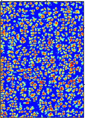
Light Detection And Ranging (LiDAR) crown detection predicts tree diameter with a correlation coefficient of 0.83.
Digital Agriculture Posts

Even if you don’t know much about beef or dairy production, if you imagine a ranch or a...
On any given day in Indiana, you will find farmers checking weather apps before sunrise,...
Keeping records of events, transactions, and important activities can be simplified using digital...

Herd records (breeding, pregnancy checks, births, weaning, treatments, etc.) have value from...
Purdue Agriculture researchers are harnessing the power of artificial intelligence (AI) and...
Purdue University’s College of Agriculture recently welcomed Ignacio Ciampitti, an...