

Researchers Add Weather Station at Martell Forest
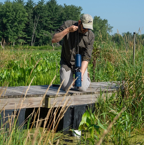
Martell Forest now has a detailed weather station on site, with professor of forestry and natural resources and biological sciences Jeff Dukes spearheading the project and Indiana state climatologist Beth Hall of the Indiana State Climate Office offering her full support.
"We have a Department of Energy project that is getting started at Martell Forest, a throughfall exclusion plot, and we really need to have a better sense as to how much precipitation there is in the area," Dukes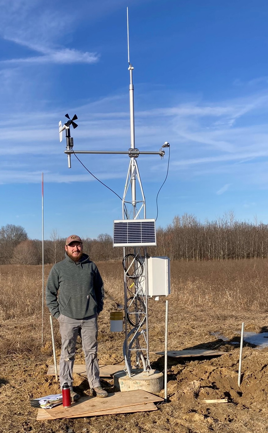 said. "And if I was going to invest in a weather station, I thought 'let's make it a good one' and if it can be something that benefits other people all the better. I talked to Beth Hall, our state climatologist, about how the Mesonet stations she runs work and this sounded like a good opportunity to tie a weather station that could be used by anybody working at Martell into a network that would make the data much more widely available. This new device will help fill some much-needed local data requests, while providing on-the-spot wind and temperature reports."
Dukes' "Understanding spatial and temporal drivers of variation in tree hydraulic processes and their consequence for climate feedbacks" project has a total budget of $1 million over the next three years. The research aims to understand how different tree species acclimate to water stress over time. It will look at how trees that have been exposed to water stress in the past respond to drier soil conditions and if they respond differently than trees of the same species that haven't been exposed to chronic dry soils in the past. Over the past few years, researchers have created different strips of a hillside that get different amounts of precipitation, including some that have been forcibly manipulated to be chronically dry. Moving forward, the project will:
- assess how acclimation affects tree growth and carbon storage across landscapes and drought episodes
- develop a model-compatible database of hydraulic traits and responses across species, landscape contexts and seasonal weather variation through comprehensive measurements of plant hydraulic properties at targeted field sites
- extend the model-compatible database to encompass drier conditions than occur naturally on the landscape by measuring hydraulic properties of tree species exposed to chronic experimental drought at two forest sites in Indiana.
Once the weather station components were ordered, farm manager Brian Beheler and his crew worked with Dukes to find a suitable location, before laying the foundation and completing the setup for the Mesonet station.
Data from the weather station can be seen on the Purdue Mesonet Data Hub website. Click on the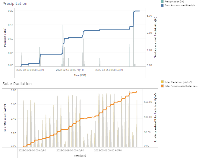 Martell Forest dot on the map and a new window with options for 30-minute, hourly and daily data will appear.
Current data points include:
- air temperature (Fahrenheit)
- relative humidity (percentage)
- precipitation (inches)
- accumulated precipitation (inches)
- solar radiation (kW/m2)
- wind speed (mph), wind direction)
- wind gust (mph)
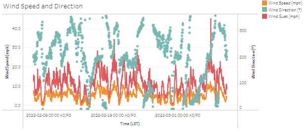 After the winter freeze season, soil temperatures and moisture will be added to the available datasets, making the weather station fully functional. Data is sampled every three seconds and transmitted for archiving at 30-minute intervals.
Researchers will have access to more data beyond the local station as the Martell Forest Mesonet station is tied into the larger statewide Mesonet network, which includes a location at the nearby Agronomy Center for Research and Education (ACRE).
"This allows us to understand the local scale variation in temperature and precipitation a little bit better because we do have a site out at ACRE, which is not that far away," Dukes explained. "When we get thunderstorms popping up in the summer sometimes we don't we don't know if ACRE is going to miss a storm that we get at Martell or vice versa. There just wasn't anything really close enough, so now this station will give us a better localized point of comparison."
The comparative data this gives to Hall and her colleagues across the country can assist in both station maintenance and the understanding of local weather conditions.
"Since the Martell station is so close to ACRE and Throckmorton, the advantages it brings are for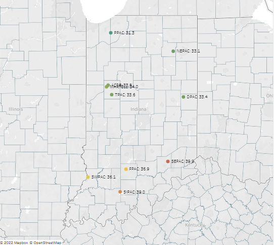 redundancy and quality assurances," Hall said. "These are very important issues when we're relying on sensors that could deteriorate over time, but still provide physically plausible data. Without comparative data, we may not know there are issues. In contrast, assuming all sensors at all three weather stations are fine, it is useful to monitor the microclimate influences that may be occurring within a more forested region that we wouldn't see in a row crop agricultural environment.
"We utilize this type of data to correlate weather with environmental responses nearby. For example, if plant diseases develop it would be useful to see how weather variability and/or extremes may have played a role. The National Weather Service utilizes data from these stations to better understand the local weather conditions that they may not get from other weather networks (e.g., winds, humidity, solar radiation). Hydrologists would utilize the data to better understand relationships between precipitation, evapotranspiration, and soil conditions. Fortunately, weather and climate affect so many things. The more data we have, the better we can understand environmental responses and impacts."
Featured Stories
Several Forestry and Natural Resources students, staff and recent alumni have been recognized for...
A plume of contamination spreads underground. A building's foundation weakens. A wetland...
Jarred Brooke, Extension wildlife specialist, was honored with a Career Achievement Award at the...
Sophomore forestry major Brett Cox recaps week 2 of the Sustainable Natural Resources study...

Morgan Hamilton, a rising senior majoring in aquatic sciences, has had an...
Throughout the 2026 Sustainable Natural Resources study abroad course in Sweden...