

New soil moisture and temperature data helps predict life-threatening Indian monsoon rains
Thunderstorms embedded within Indian monsoon systems can deluge areas with dozens of inches of rain in little time, causing severe flooding and the loss of hundreds of lives each year. Better predictions of when, where and how much rain will fall is key to saving property and lives.
A collaboration, led by Purdue University’s Dev Niyogi, professor of agronomy and Earth, atmospheric and planetary sciences, with colleagues from the Indian Institute of Technology Bhubaneswar, the National Institute of Technology Rourkela, the Chinese Academy of Meteorological Science, the Indian Ministry of Earth Sciences and the U.S. National Center of Atmospheric Research developed multi-decade soil moisture and soil temperature fields using variety of surface and satellite data. They have shown that fine-scale data, never before available for India’s monsoon regions, is a critical ingredient to understanding and improving predictions of how violent storms will behave over land.
Just as storms change behavior based on the landscape – such as moving from water to land – or from encountering a cold or warm front, they also react to changes in wet or dry and warm versus colder soils.
“For a long time Indian monsoon research has focused as an oceanic feedback, but in recent years we have seen localized heavy rain embedded within thunderstorm events with flooding and cloud bursts that occur over land,” said Niyogi, whose findings were published in the journal Scientific Data. “These thunderstorms often flare up because they’re responding to a boundary – meaning an edge of a different environment. What we have learned is that gradients in soil moisture and soil temperature help create an atmospheric frontal boundary and can unleash violent reactions from a storm. Understanding these locations climatologically is therefore quite important to help these predictions.”
Niyogi and colleagues worked more than three years on an intensive, collaborative project that was supported by the U.S. National Science Foundation and the India’s Ministry of Earth Sciences under the National Monsoon Mission to compile different datasets and assimilate global satellite soil moisture and soil temperature data from 1981-2017 and beyond. Their product now provides gridded data every three hours for every 4 km parcel of land giving soil moisture and temperature in India. Combined with observed weather during that period, the data can improve models used to predict future storms.
“This data is useful for a host of applications, including to help make decisions about where to grow crops or places in which we can adapt to prevent flooding or erosion,” Niyogi said.
Niyogi added that the data collection was possible because of the investment India has made through its Monsoon Mission and the partnership Purdue has created with the Indian government and scientists.
“Working together, between Purdue and the Indian teams, as well as the support we got on both sides, we could create a product that has been desired for a number of decades now,” Niyogi said. “It’s really heartening to see that at the intersection of technology and human collaboration, ideas can be converted into useful products.”
Hara Prasad Nayak, Raghu Nadimpalli, Palash Sinha and U C Mohanty from IIT Bhubaneswar, Krishna Osuri from NIT Rourkela, and M. Rajeevan, secretary of the Ministry of Earth Sciences in Indian side, with Fei Chen from the National Center for Atmospheric Research in the United States, participated in the study with Niyogi at Purdue.
The study benefitted primarily from Indian Ministry of Earth Sciences, U.S. National Science Foundation and the U.S. Department of Agriculture’s National Institute for Food and Agriculture.
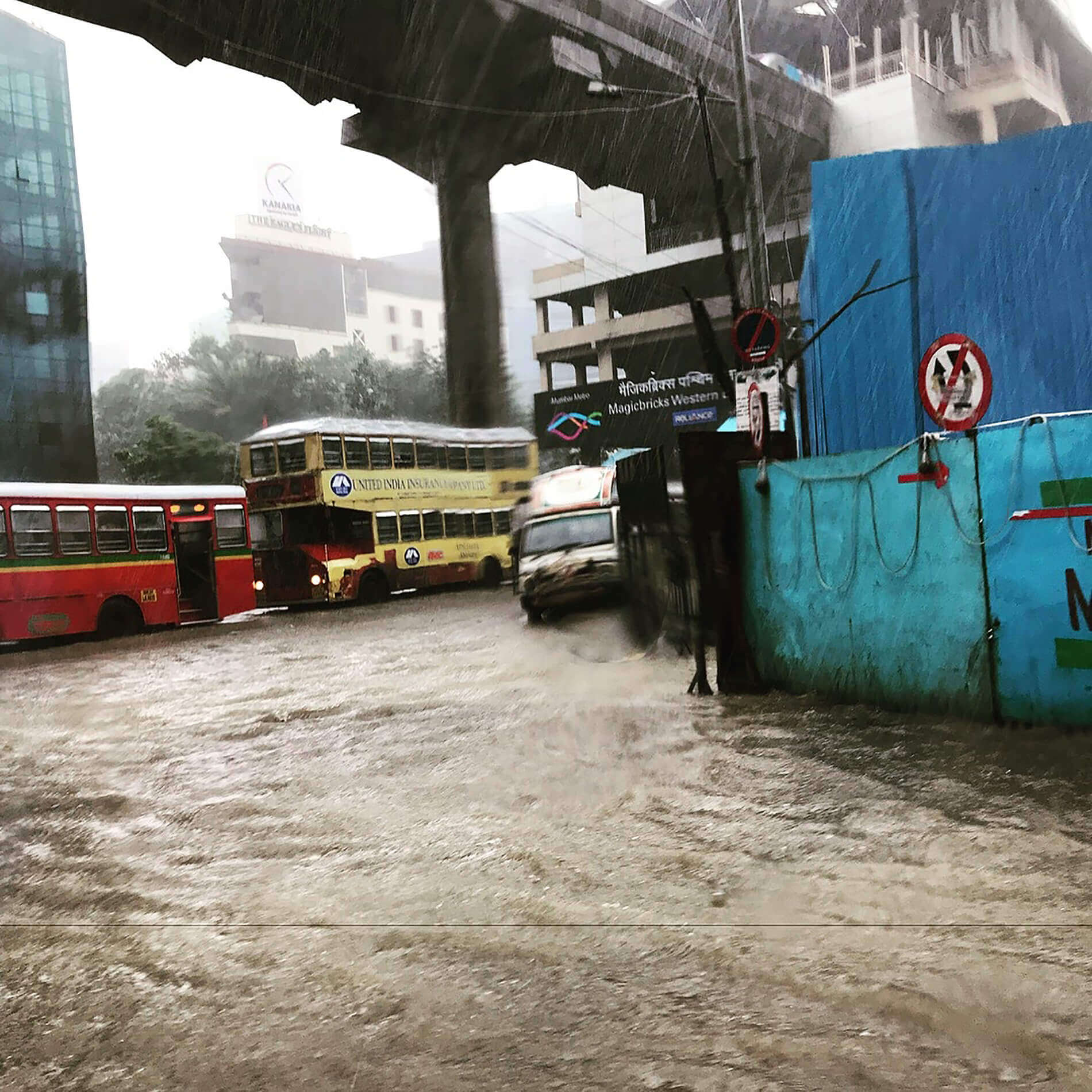 Heavy rainfall during 2017 Indian summer monsoon season floods Mumbai streets. These events can cause catastrophic loss of property and life, but new dataset developed by a collaboration led by Purdue University may help improve predictions and reduce damage. (Photo credit: Aditya Kuber, Mumbai)
 Featured Stories

By learning how to cut through the hype and focus on what truly matters, you can shop smarter...

Channing Arndt, research professor in agricultural economics and director of the Global Trade...
Daniel Szymanski and his former postdoctoral scholar Youngwoo Lee, lead author on their paper...

The Costa Rica Rainforest Experience study abroad trip allowed students to experience the wonders...

Trask is writing a new narrative about rats, birds and people as he pursues his doctorate in...

Several Forestry and Natural Resources students, staff and recent alumni have been recognized for...