

Researchers Develop Tools to Assess Habitat Selection, Suitability for Bobcats
 Bobcats (Lynx rufus) disappeared from much of the midwestern U.S. during the 20th century. The population in Indiana was one of the last to begin rebounding in the late 1990s. However, much of the previously suitable habitat, predominantly forest, had been converted for human use over time.
Former postdoctoral researcher Landon Jones along with Drs. Rob Swihart and Pat Zollner and members of the Indiana Department of Natural Resources have been collaborating to develop tools to help wildlife researchers assess the habitat selection of and habitat suitability for bobcats in Indiana and surrounding areas.
Findings from their research were recently published in two papers: “Estimating statewide carrying capacity of bobcats (Lynx rufus) using improved maximum clique algorithms” in Landscape Ecology and “Habitat selection in recovering bobcat (Lynx rufus) population” in Plos ONE.
In order to assist wildlife managers in assessing the maximum number of individual animals a landscape can support, also called landscape carrying capacity, researchers utilize a mathematical graphing theory called maximum clique analysis. MCA uses data including home range size and landscape maps of habitat suitability, selection and occupancy to predict the landscape carrying capacity for a species. Limitations on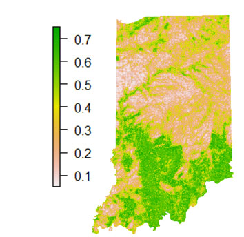 MCA, however include lack of software availability in common formats, and computational constraints due to an overwhelming number of possibilities.
“The goal of our study was to estimate the number of territories for female bobcats that the remaining suitable habitat in the state could support,” explained Jones, who is now a research associate with the department of wildlife fisheries and aquaculture at Mississippi State University,. “We extended an existing quantitative approach called maximum clique analysis (MCA) to estimate landscape carrying capacity. We applied updated algorithms and created user-friendly coding scripts to make MCA more feasible and less computationally intense for wildlife researchers to calculate for bobcats and other territorial species. We also created a way to calculate confidence intervals as uncertainty estimates for landscape carrying capacity.”
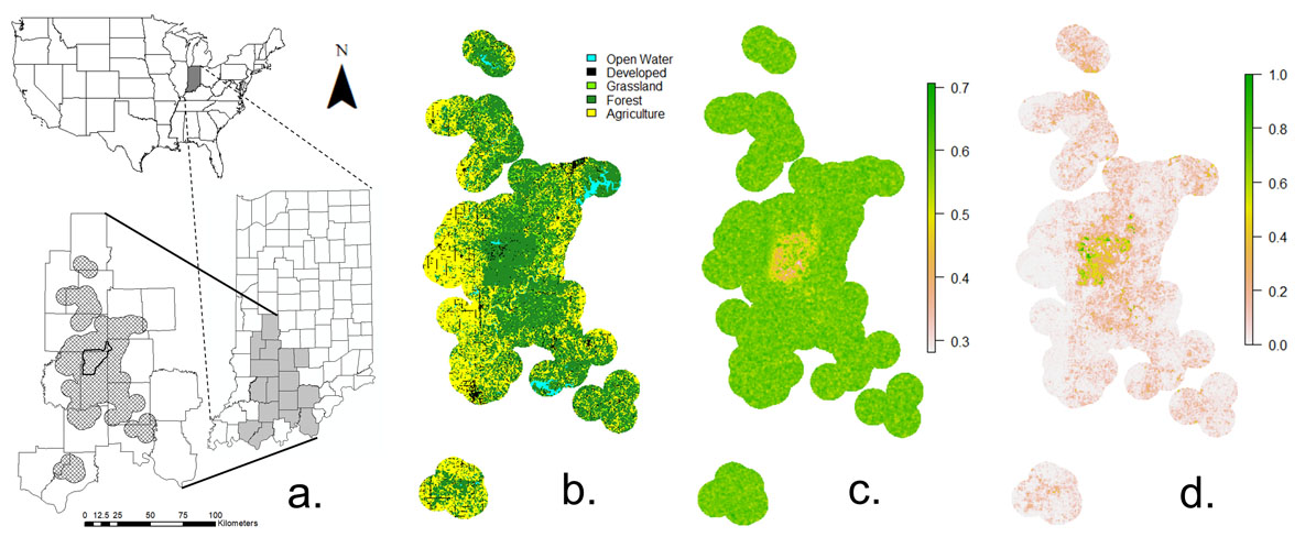 Figures demonstrating bobcat habitat suitability in Indiana.
 The extended method to calculate MCA and the new method to calculate uncertainty around territory estimates will allow researchers to estimate how many potential territories can fit in any given landscape. This can be a conservative estimate for population size in an area and give wildlife managers an idea of the size of population an area can support, which is especially useful when considering or improving management options. These estimates can be particularly important for species such as carnivorous mammals that are secretive, can move over large areas, and tend to have large home ranges.
“Our method will be particularly informative in understanding the potential of a landscape to support territorial animals for reintroduction or where small or declining populations are rebounding or expanding,” Jones said. “Our method applies to other territorial species and taxa as well. Improved estimates of landscape carrying capacity can help wildlife managers make optimal management decisions to improve or maintain populations of territorial species. We believe our methods will permit more mainstream wildlife managers and researchers access to this powerful approach where bottlenecks of computer expertise and computational limitations typically presented a large barrier to conducting analyses to quantify landscape carrying capacity for territorial wildlife species.”
In addition to updating the computational methods used to measure predict landscape carrying capacity, researchers also worked to understand the habitat selection process of the bobcats to predict their impacts on ecological communities and interactions with humans. The findings of that work are published in the article “Habitat selection in a recovering bobcat population.”
“The goal of our study was to determine habitat selection for the newly rebounding population in the nucleus of the area where they were expanding in the state,” Jones said. “We used a newer approach to estimate habitat selection by applying a machine-learning approach called Random Forest, which has not been applied to bobcats. This approach showed us more fine-scale selection of bobcat habitat use compared to previous bobcat studies. For example, bobcats at our site concentrated their use of forest within 500 meters of forest edges with other habitat types.
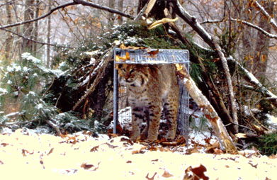
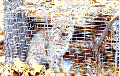 Bobcats were trapped and tracked via radio telemetry from December 1998 to April 2006. Locations from tracking were imported into geographic information system for analysis. Using machine learning and a random forest model, that data helped researchers create a better picture of the preferred habitat of the bobcat in Indiana.
“Our results in Random Forest qualitatively agreed with results from previous bobcat studies, but produced more refined patterns that improve understanding of bobcat habitat use for managers. Using the Random Forest approach to quantify habitat selection can improve information managers can use to manage bobcat populations, where they have expanded in Indiana, but also in other states with stable or harvested populations. This approach can be applied to any species to gain improved understanding over traditional habitat selection methods.”
The publication concludes by stating the potential applications of the study.
Our results imply that bobcats in our study area would benefit most from maintenance of forested areas further from other habitat types. Additionally, our results indicate that bobcats view anthropogenic boundaries such as roads, development and agriculture in terms of context-dependent tradeoffs and not as simple selection or avoidance of these features. Such complex behavioral tradeoffs likely apply more broadly to other carnivore species, especially those inhabiting human-dominated landscapes.
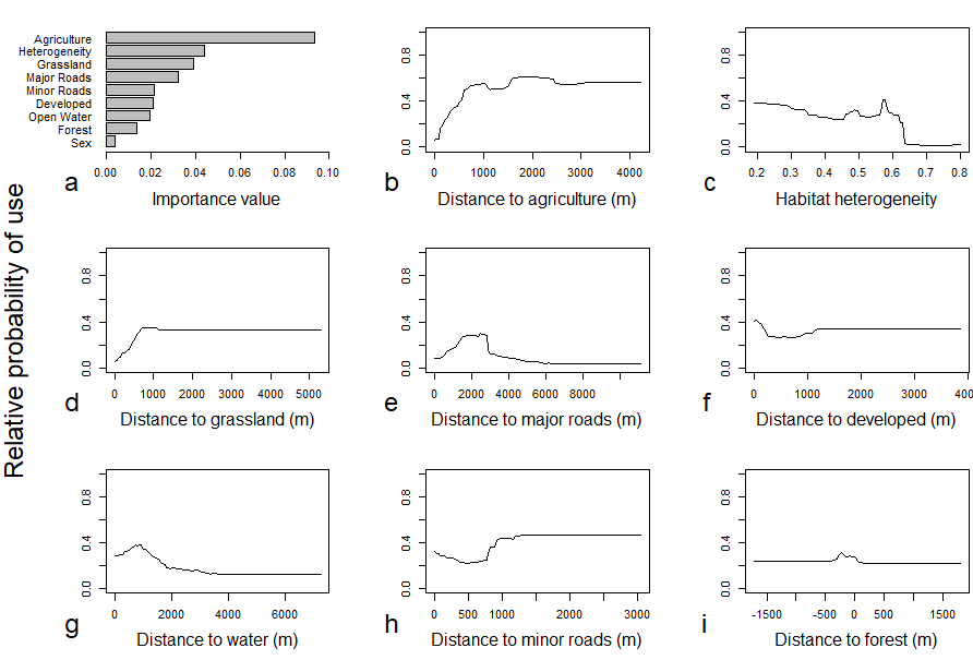 Relative probability of land use by bobcats in chart form for importance value, distance to agriculture, habitat heterogeneity, distance to grassland, distance to major roads, distance to developed areas, distance to water, distance to minor roads and distance to forest. (Values from 0-1; 0 is not suitable and 1.0 is 'ideally' suitable)
 Indiana Department of Natural Resources furbearer biologist Geriann Albers explained how information from both studies can be useful for the DNR and wildlife managers across the country.
“It’s really great Landon and the Purdue team were able to work out these improved techniques for max clique analysis using the wealth of information we had on our thriving bobcat population,” Albers said. “While common in southern Indiana and expanding in northern Indiana, this analysis helps us understand how bobcats will continue to expand. On top of that, this technique is now another tool in the toolbox when wildlife managers in Indiana and beyond think about trying to recover some of our species that are endangered. Information about carrying capacity in available habitat can be important to setting recovery goals for endangered species. By being able to make these improvements to the technique with something that is doing great, like bobcats, it will now benefit other animals we’d like see doing well in the future.
“The habitat work is another example of researchers improving methods over time. The habitat selection, while in line with what we expect, provided a finer scale of what makes up bobcat habitat. It helps us understand which parts of Indiana will be good for bobcats and which will be more marginal. These two techniques combined with other information also get us closer to another valuable tool to ensuring bobcat populations stay healthy in Indiana, a population model. It is amazing work and we are happy to have partnered with Purdue University for these efforts to keep bobcats healthy and thriving in Indiana.”
Featured Stories

Several Forestry and Natural Resources students, staff and recent alumni have been recognized for...
A plume of contamination spreads underground. A building's foundation weakens. A wetland...

Jarred Brooke, Extension wildlife specialist, was honored with a Career Achievement Award at the...

Sophomore forestry major Brett Cox recaps week 2 of the Sustainable Natural Resources study...

Morgan Hamilton, a rising senior majoring in aquatic sciences, has had an...

Throughout the 2026 Sustainable Natural Resources study abroad course in Sweden...