Forestry & Natural Resources
Digital forestry team combines AI with satellite data to monitor urban trees
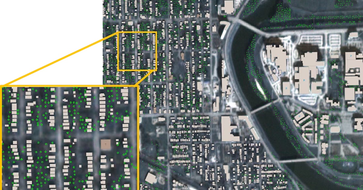 These images were generated by a team at Purdue’s Institute for Digital Forestry to show the locations of individual trees in a neighborhood of Indianapolis, Ind. (Purdue University Institute for Digital Forestry)
 New method offers fast, accurate results for city planners and policymakers
WEST LAFAYETTE, Ind. — A Purdue University digital forestry team has created a computational tool to obtain and analyze urban tree inventories on public and private lands with record-breaking speed at an unprecedented scale.
The team accomplished the feat by developing a novel AI-enhanced visual computing method that accurately determines the locations of trees in over 330 U.S. cities with a population of 100,000 or more. The method so far has individually identified 280 million urban trees.
“The most exciting aspect to me is the speed at which we can leverage satellites. The NYC Million Trees Initiative took over 2,000 volunteers more than 30,000 hours to count the street trees in New York City. We did it in an hour,” noted Adnan Firoze, a Purdue graduate student in computer science. Firoze and seven co-authors will report their results in a paper accepted for publication by Communications of the ACM.
Looking beyond the numbers and pointing to the California wildfires, Firoze highlighted the positive impact the work could have on people’s lives. “While it took general processes and the mass media months to map out the loss in vegetation and structures, our work can facilitate and quantify it the very next day,” he said.
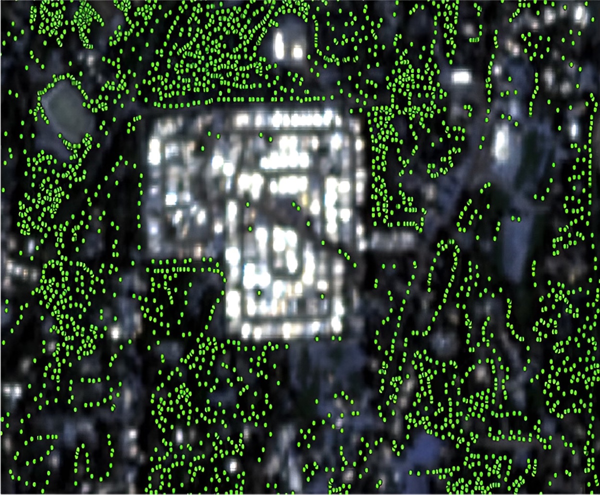 Purdue University digital forestry researchers generated these images using their new method that combines artificial intelligence with satellite data to monitor urban trees. These images show 2,792 trees before the wildfire in Kilcrease Circle, Paradise, Calif., and 747 trees afterward. (Purdue University Institute for Digital Forestry)
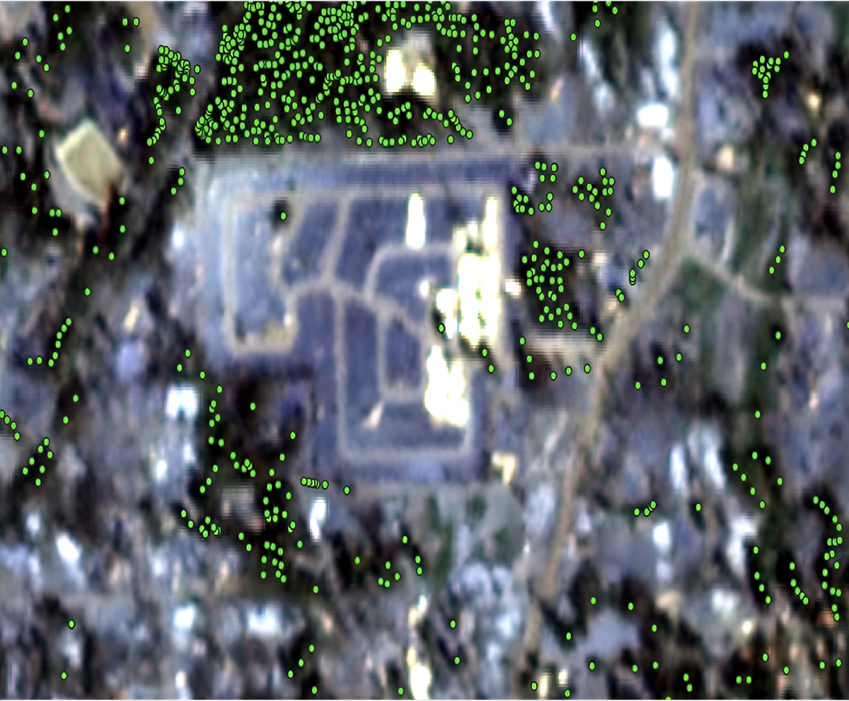
Cities such as New York, Chicago and Los Angeles have paid millions of dollars to conduct tree inventories within their boundaries. Small cities, by contrast, lack the resources to conduct such inventories, which cost $4 to $7 per tree.
These traditional inventories present challenges. They provide a wealth of information but cannot offer precise data, such as distance between trees, distance between buildings and backyard tree counts. The Purdue approach enables cities with more limited resources to conduct inventories easily, quickly and thoroughly, said Daniel Aliaga, associate professor of computer science, who led the project.
The location of urban trees tends to follow certain rules in contrast to the more random tree distributions in natural forests. To help their system better understand urban tree distribution, the researchers trained their foundational model at Purdue’s Rosen Center for Advanced Computing. The three-week training process involved 100 graphics processing units (GPUs), mainly using the Gilbreth supercomputer.
This work exemplifies how AI and digital forestry — both aspects of the Purdue Computes initiative — can help solve intractable urban issues. Purdue Computes is the university’s strategic effort to advance research and innovation in computing, physical AI, semiconductors, and quantum technologies, while expanding access to state-of-the-art computing resources. By connecting advanced computing infrastructure with disciplines such as forestry, agriculture and urban sustainability, Purdue is enabling discoveries that translate directly into real-world impact.
“The idea is to be repeatable. It takes about a day to update the dataset, to compute 330 cities,” Aliaga said. And because the data they use from the PlanetScope constellation of 130 satellites includes 15 years of historical records, the system can generate before-and-after comparisons involving forest fires and other disasters to understand their effects.
 Purdue University’s Daniel Aliaga, associate professor of computer science and a member of the Institute for Digital Forestry. Aliaga led a digital forestry team that combines artificial intelligence with satellite data to monitor urban trees.
(Purdue Agriculture Communications/Joshua Clark)
Purdue University’s Daniel Aliaga, associate professor of computer science and a member of the Institute for Digital Forestry. Aliaga led a digital forestry team that combines artificial intelligence with satellite data to monitor urban trees.
(Purdue Agriculture Communications/Joshua Clark) “We want the output to be not only a dataset, but also a methodology,” Aliaga said. “By our generative visual computing method, we’re able to respond to queries and to what-if scenarios, providing rich information about cities in an automated, easy-to-use platform.”
The researchers verified the accuracy of their results with Google’s Auto Arborist Dataset, which combines street-level, aerial and satellite images of trees in 26 cities. They further vetted their approach with data from other cities. About 100 of the 330 cities have detailed or partial information. The tree-count ground-truth accuracy averaged 92.5% across the cities. Tree locations were accurate to within 1.5 meters, or nearly 5 feet.
In recent decades, researchers like Aliaga have used standard urban modeling methods that would define rules to generate city structures and content. Purdue’s generative AI scheme has evolved into the next generation of those methods. The scheme draws upon deep learning, computer vision and image processing to chart the most likely tree locations from satellite data.
“If we discover the rules that govern the geometry and the placement of buildings and trees, then maybe we don’t need to sample every single tree,” Aliaga said. “By having example data ingested, the network learns the rules that can generate the data in a very similar distribution to reality.”
The Purdue approach produced vastly more specific results than most previous studies conducted at similar scales. Those studies only indicated areas that were green or not.
With more detailed basic information, “you can start thinking about better planning and simulating the city environment,” said Songlin Fei, professor of forestry and natural resources and director of the Institute for Digital Forestry. Fei and Ayman Habib, Purdue’s Thomas A. Page Professor of Civil Engineering, are the cofounders of the startup Arbomapper, which delivers a solution developed alongside this initiative.
Fei noted that city infrastructure changes the weather, creating an urban heat island effect that alters the environment. “We can plant trees to better mitigate the heat island effect,” he said.
Carefully distributing trees and vegetation also could help make a city landscape more wildfire-resistant. “If you plant trees too close to your house, this could be fuel for wildfires,” Fei said.
Tree density also reveals relationships to social and economic issues when correlated with census data. For example, the Purdue study reinforced findings by other researchers showing that higher-income neighborhoods enjoy a greater tree density than less-well-to-do areas.
“Natural forests are places that not many people encounter on a day-to-day basis,” Fei said. For city dwellers, however, urban trees and forests are a routine part of everyday life. The United Nations has projected that 70% of the world’s population will live in cities by 2050, up from 55% in 2022. “The city landscape matters a lot,” he said.
The team is currently developing a national-scale web portal for urban green (i.e., trees) and gray (i.e., buildings) inventory estimation and analysis. This work was funded by the National Science Foundation, the U.S. Department of Agriculture and Purdue’s Institute for Digital Forestry.
Computer science and AI are cornerstones of Purdue Computes — a comprehensive initiative that spans computing departments, physical AI, quantum science and semiconductor innovation.
About Purdue Computer Science
Founded in 1962, the Department of Computer Science was created to be an innovative base of knowledge in the emerging field of computing as the first degree-awarding program in the United States. The department continues to advance the computer science industry through research. U.S. News & World Report ranks the department No. 16 and No. 19 overall in undergraduate and graduate computer science, respectively. Graduates of the program are able to solve complex and challenging problems in many fields. Our consistent success in an ever-changing landscape is reflected in the record undergraduate enrollment, increased faculty hiring, innovative research projects, and the creation of new academic programs. Learn more cs.purdue.edu.
About Purdue Agriculture
Purdue University’s College of Agriculture is one of the world’s leading colleges of agricultural, food, life and natural resource sciences. The college is committed to preparing students to make a difference in whatever careers they pursue; stretching the frontiers of science to discover solutions to some of our most pressing global, regional and local challenges; and, through Purdue Extension and other engagement programs, educating the people of Indiana, the nation and the world to improve their lives and livelihoods. To learn more about Purdue Agriculture, visit this site.
About Purdue University
Purdue University is a public research university leading with excellence at scale. Ranked among top 10 public universities in the United States, Purdue discovers, disseminates and deploys knowledge with a quality and at a scale second to none. More than 107,000 students study at Purdue across multiple campuses, locations and modalities, including more than 58,000 at our main campus in West Lafayette and Indianapolis. Committed to affordability and accessibility, Purdue’s main campus has frozen tuition 14 years in a row. See how Purdue never stops in the persistent pursuit of the next giant leap — including its comprehensive urban expansion, the Mitch Daniels School of Business, Purdue Computes and the One Health initiative — at https://www.purdue.edu/president/strategic-initiatives.
Writer: Steve Koppes
Media contact: Devyn Ashlea Raver, draver@purdue.edu
Sources: Daniel Aliaga, aliaga@purdue.edu; Songlin Fei, sfei@purdue.edu; Adnan Firoze, afiroze@purdue.edu
Agricultural Communications: Maureen Manier, mmanier@purdue.edu, 765-494-8415
Journalist Assets: Publication quality images can be obtained at this link