

Digital foresters embrace GIS mapping and analysis
Purdue University has grown a thriving forest of more than 2,000 geographic information systems (GIS) users across campus. The largest numbers come from the colleges of Agriculture, Engineering, Liberal Arts, and Science.
GIS and the Institute for Digital Forestry, among other Purdue academic disciplines, have grown together like trees with intertwined canopies. GIS enables users to create, manage, analyze and map data in fields such as the humanities, civil engineering, political science, and earth, atmospheric and planetary sciences.
Purdue Libraries and the School of Information Studies stand at the hub of GIS at the university. “We have a large digital forestry group that is highly interested in remote sensing-related work,” said Gang Shao, associate professor at Purdue Libraries.
Shao and Nicole Kong, professor and associate dean for research at Purdue Libraries, are both members of the Institute for Digital Forestry. “We work specifically on the geospatial information side,” Kong noted.
As a designated Esri Innovation Program, Purdue offers special interdisciplinary training and recognition opportunities to students through the Libraries. Esri sponsors the annual EIP Student of the Year Award for outstanding achievements in developing innovative tools, applications or techniques using the ArcGIS platform.
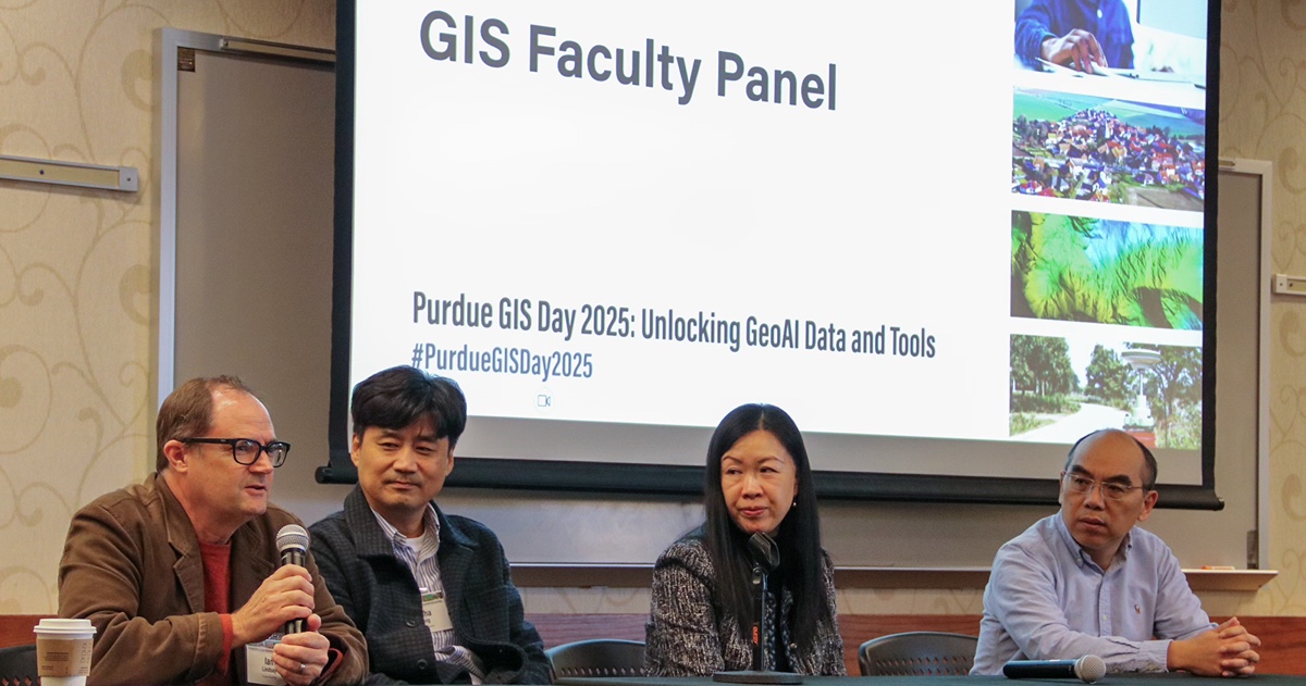 The 2025 GIS Day at Purdue included a faculty panel discussion. Participating faculty (from left), were Ian Lindsay, associate professor of anthropology; Jinha Jung, associate professor of civil engineering; Nicole Kong, professor and associate dean for research at Purdue Libraries; and Songlin Fei, director of the Institute for Digital Forestry and professor of forestry and natural resources.
 Receiving the award each of the last two years were PhD candidates in forestry and natural resources who conducted research in the Institute for Digital Forestry. Yunmei Huang and Christopher Ardohain received the awards in 2025 and 2024, respectively.
Huang leveraged artificial intelligence and ArcGIS field maps in her project, “Field-Ready Tree Species Identification using Explainable AI.” Ardohain used ArcGIS Pro 3.03 in his project, “Training Data Spatial Scales and Deep Learning Performance.”
Purdue is among the universities nationwide that annually observe GIS Day. The Libraries sponsored Purdue GIS Day 2025 in early November gathered more than 200 students, faculty, staff and professionals who have interdisciplinary GIS interests. This year’s theme was “Unlocking GeoAI Data and Tools,” and the event’s corporate sponsors were AWS, Cultivate Geospatial, Ecopia, and Esri.
Highlights from this year’s GIS Day presentations included posters from undergraduate and graduate students from across campus. Contributing to the presentations were students from agricultural economics, agronomy, forestry and natural resources, and horticulture and landscape architecture. GIS Day keynote speaker Gregory Brunner, Esri principal data scientist, headlined industry contributions with his comments on “Integrating AI across GIS.”
The School of Information Studies offers a graduate certificate program in geospatial information science, as well as undergraduate courses. Geographic information systems and geospatial information science involve the tools and methods for mapping and analyzing geographic locations. The latter term encompasses the technology more broadly but always associates the data with a specific location. The former term applies to geographic software that integrates both spatial and non-spatial data.
 Zachary Horve, a graduate student in forestry and natural resources, presents research on “Characterizing forest structural and biodiversity relationships across spatial scales and climate gradients in the eastern United States at the 2025 GIS Day at Purdue.
Forty-eight students have graduated from the GIS certificate program since its launch in fall 2021. Another 76 students have recently been admitted, with almost half coming from the College of Agriculture’s departments of agricultural and biological engineering, agronomy, botany and plant pathology, and forestry and natural resources.
The Institute for Digital Forestry has also recently introduced its Professional Master’s in Digital Natural Resources Program among its additional efforts to prepare the next generation of digital foresters. The program includes a Digital Data Acquisition Certificate and an option for geographic information systems certification. Undergraduates have the option to minor in digital natural resources.
Computer science and AI are cornerstones of Purdue Computes — a comprehensive initiative that spans computing departments, physical AI, quantum science and semiconductor innovation.
Featured Stories

Trask is writing a new narrative about rats, birds and people as he pursues his doctorate in...
Several Forestry and Natural Resources students, staff and recent alumni have been recognized for...
A plume of contamination spreads underground. A building's foundation weakens. A wetland...
Jarred Brooke, Extension wildlife specialist, was honored with a Career Achievement Award at the...

Sophomore forestry major Brett Cox recaps week 2 of the Sustainable Natural Resources study...

Morgan Hamilton, a rising senior majoring in aquatic sciences, has had an...