

Brady Hardiman named 2026 University Faculty Scholar for bringing communities and trees together to grow better cities
Brady Hardiman, associate professor of forestry and natural resources and sustainability engineering and environmental engineering, has been named a 2026 University Faculty Scholar for his research in the Institute for Digital Forestry on urban forestry, remote sensing, ecology and social science.
When you think of forests, you likely picture yourself deep in the woods under dense canopies — surrounded by wildlife and miles away from the nearest human civilization. While those forests are important, Hardiman focuses on the greenery closer to home, where people more frequently interact with plants and trees in their cities and local parks than they do in isolated forests.
Hardiman’s research is part of the Purdue Computes Initiative
This initiative focuses on using the latest innovations in technology and artificial intelligence to solve complex issues around the world.
Learn MoreHardiman’s lab studies the intersection of plants, people and the places that both occupy. Modern technology — from lasers that help identify the shapes and structures of forests and cities, to computer algorithms that read satellite images — is answering fundamental questions about how plants in the city affect the temperatures, local biodiversity, energy costs, financial wellbeing and health of people living there.
Q&A with Brady Hardiman
How would you define your research background?
I spent all my summers growing up on my grandparents farm in Ohio, and we had total freedom to just be outside all the time. We spent a lot of time in the woods, climbing trees and playing in the creek and making forts. I remember just lying on my back, staring up through the trees, daydreaming. Since then, I have always wanted to work in forests.
My bachelor's degree was from a small liberal arts university in north central Ohio, called Ashland University. I was a biology major, and I ended up taking classes in genetics, cell biology, botany, ecology and biochemistry. The interdisciplinary background has been really important to my career in ways I couldn’t have predicted.
I started my PhD at Ohio State University in a forest ecology lab, and did field work for six months a year for six years at the University of Michigan Biological Station. Then I graduated and started a postdoc at Boston University in a forest ecology lab where I did experiments in the White Mountains in New Hampshire and Western Upper Peninsula Michigan. And then an opportunity came up to switch to another lab, and this one was doing urban ecology.
Any tree or plant within city limits, whether on the side of a busy road or in a local park, is a part of the urban forest. They may not be the most dense forests, but they are equally as complex, and they benefit the industries, wildlife and people living nearby. Urban ecologists and foresters study the impact of these ecosystems on each other and find solutions to improve them.
What key projects have shaped your research and its direction?
During a National Science Foundation research experience for undergraduates at the Harvard Forest Long Term Ecological site and my PhD at Ohio State, I would go up in the tree canopy on an aerial work platform and be there for eight hours a day taking measurements. I watched the forest and wildlife from a bird’s-eye view. I saw how the wind moves through the trees, how the light changes over the course of the day and how it filters through the canopy.
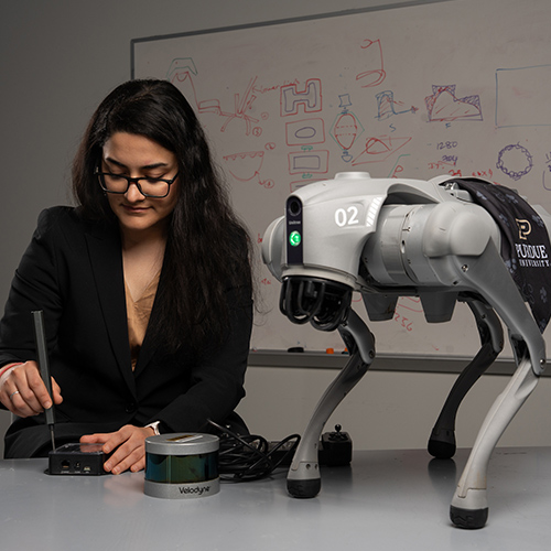
I was always interested in tree canopies and studying them, but you can climb only one tree at a time to measure the canopy. So, I came up with the idea of making balloons that can carry light sensors up through the canopy. My advisor sent me to spend a week at the Smithsonian Environmental Research Center with a scientist to learn how to use terrestrial lidar. The following summer, he loaned me the lidar, and I spent a summer at the University of Michigan Biological Station, scanning all the trees.
Lidar stands for Light Detection and Ranging — it's like radar but uses lasers to measure distance. Whether attached to stationary tripods or moving planes and drones, it shoots laser pulses around it. Those hit different objects in the environment and bounce back, and a timer measures how long it took for the light to travel back. Charting these reflections over time gives an accurate 3D map of the structures around, like trees and buildings.
What’s the most exciting aspect of your research?
I love the deep forest, and I never expected to transition into urban forestry. But, since urban ecology is a much younger field than forest ecology, I was excited for the opportunity to ask fundamental questions and follow the thread of how the environment is connected to how people live.
Over the years, my lab and I have been leading diverse projects to grow greener cities through trees under three key research areas:
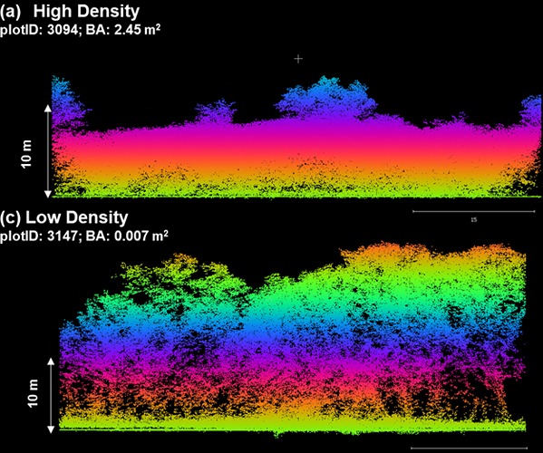
More structurally complex canopies, containing a wider variety of levels of leaves and branches, can take up and store carbon, buffer wind, prevent erosion and provide habitats for wildlife. Remote sensing technology like satellite imaging and lidar help us see how the tops of forests and buildings in a city are distributed and how they interact with their environment.
Collecting data on the ecological and economic benefits trees provide to people in cities
Trees, shrubbery and other plants can lift someone’s mood just by providing calming greenspaces. They also filter air and water, cool the city with their shade and natural water cycling, and reduce energy usage and costs. Our data can help city planners protect and prioritize plants in their city.
Understanding legal and social systems that impact city design
A lot goes into designing and living in cities. We collaborate with social scientists to study how ecology interacts with policy, economic and other social factors, and predict how all those might change in time and under climate change. Well-thought out and distributed vegetation can lead to more equitable, healthier communities.
If you want to help trees improve people's lives, urban forests are the best places to do that.”
- Brady Hardiman, associate professor of forestry and natural resources and environmental and ecological engineering
What motivates your work?
Most of our world lives in cities, and more and more people are moving to them. We want to take the information we learn to develop tools that allow community members to know what their urban forests look like and what benefits they provide their city. How many trees do they have? What kind of trees are they and will those trees tolerate disease and temperature changes? How much carbon are they storing? How much pollution are they mitigating? How much energy are they saving? How are greenspaces different between richer and poorer neighborhoods, and how can we make those more equitable?
My lab and our collaborators work to put that information in the hands of the people who need it — the end users, the community groups, the decision makers — and it allows them to make more informed decisions and to advocate for their needs, either in planting new trees or better management of what is already growing.
Within the Institute for Digital Forestry, we’re collaborating with colleagues in computer science to build the web platform uTREE, which uses artificial intelligence to analyze satellite images and colors — different species’ leaves change colors at different times in the year — to identify where trees are in every city, what species each is and monitor their condition across the nation.
uTREE provides information about the health and biodiversity of the forest and what services the forest might be giving the community. It can predict how changes to the forest will affect the city or vice versa. Input that you want to increase the tree canopy size in a neighborhood by 20%, for example, and it will predict the reduction to asthma rates and storm water runoff. It’s free to the public, so urban foresters and city planners can access critical information to make the best decisions about what kind of trees they should be planting and where to put them.
In what ways has Purdue’s College of Agriculture contributed to your success?
Purdue is special because it has great programs in both agriculture and engineering. I find that it's when ecology and engineering bump into each other that we have the greatest innovations. I'm really fortunate that I have this joint appointment between forestry and engineering. Having a foot on both sides of Mitch Daniels Boulevard allows me to get engineers to think about ecology problems and get ecologists to think about what sort of information engineers need to solve those problems. Engaging in both disciplines is a lot of fun for me, and I think it has benefited the research we do and the impact we have as a university.
What’s next for you?
Given the importance of interdisciplinary education in my career, I hope to give that to my students. I have both engineering students and forestry students, and I make sure they are learning from each other. We simultaneously bring in physiology, ecology, remote sensing, social science, policy, management economics — all of it, together, to provide holistic information for communities.
Forests, cities and people don’t exist in isolation. We’re all impacted by one another, and as a University Faculty Scholar, I’m working to figure out how we can make the world better for everyone.
Featured Stories
Purdue Agriculture researchers are harnessing the power of artificial intelligence (AI) and...
We tend to think of green landscapes as healthy ones. But Brady Hardiman, an associate professor...
An army of bow saws and boots march through dense thickets of forest patches in the Chicago...
With 89% of the U.S. population and 68% of the world population projected to live in cities by...