Skip to Main Content

Choose the Path of Least Resistance for Your Data

Do you know how to choose the right pathway to move the data you collect?wang-presentation-image-1.png


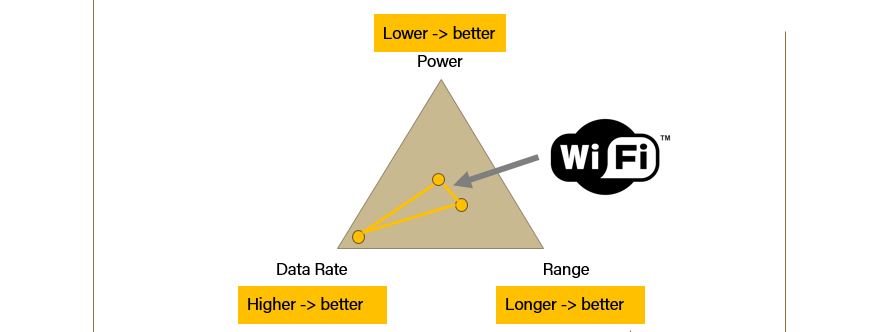
In this presentation, Yang Wang, a PhD candidate in the Open Ag & Technology Systems (OATS) Center, reviews options around rural wireless communications in a three-part tutorial. Get a better understanding of radio frequency (RF) essentials, learn how to decipher key RF parameters via visualizations and how to use readily-available information from datasheets to compare and choose appropriate protocols from four wireless modules/protocols (Bluetooth Low Energy, ZigBee, LoRa and WiFi) based on a real-world scenario.

View the Choose the Path of Least Resistance for Your Data video at https://youtu.be/Cx_jdX0wbWI 

This video presentation is part of the Digging into the Data Pipeline webinar series hosted by the College of Agriculture at Purdue University.

View the Digging into the Data Pipeline playlist on Youtube.

This series was supported in part by the Wabash Heartland Innovation Network (WHIN).

Digital Agriculture Posts

Field of corn with sun shining in background
Ignacio Ciampitti returns to Purdue as co-director of IDAAS and professor of agronomy

Purdue University’s College of Agriculture recently welcomed Ignacio Ciampitti, an...

Read More
Close-up of Hunsoo Song in front of the pink blossoms of a crabapple tree
Hunsoo Song, the civil engineer who speaks (in algorithms) for the trees

Fire, metal, water, earth and wood. In South Korean tradition, these five elements explain...

Read More
Tomi Lori Ankita looking at tomato
Purdue-led TOMI project receives $3.5M grant to turn a decade of data into new tools and strategies for tomato farmers

Indiana ranks third in the nation for tomato production. Lori Hoagland, a professor in Purdue...

Read More
Purdue research team uses a computer on top of a drone to gather data
Purdue researchers acquire and analyze data through AI network that predicts maize yield

Artificial intelligence (AI) is the buzz phrase of 2024. Though far from that cultural spotlight,...

Read More
Siddhartho Paul and his students use a RTK GPS in a soybean field to get precise location information
Satellites and soils: NIFA and AgSEED grants fund remote sensing data collection and machine-learning models to predict soil properties at farm-to-landscape scales

The few inches of soil you pick up on the tip of your shovel are part of a much bigger picture....

Read More
uav data on a monitor
Data-Driven Seminar Series

Purdue College of Agriculture presents a seminar series featuring experts in data science,...

Read More
To Top