

Forestry & Natural Resources
Shao's Work on Map Accuracy Confirmed in New Publication
It is not uncommon for a researcher to publish the findings of his/her work after testing particular hypotheses. Having industry colleagues dedicate an entire paper to confirming one’s work is a bit more rare, but it is exactly what happened to Dr. Guofan Shao recently.
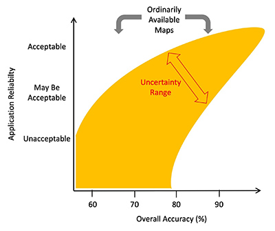
“Overselling overall map accuracy misinforms about research reliability,” a paper published by Shao in August 2019, challenged the use of the overall accuracy metric in Earth resource remote sensing. Shao, and his co-authors L. Tang and J. Liao, both based in Xiamen, China, declare that the use of overall accuracy as the single metric for map assessment is flawed and that it must be used in conjunction with other metrics.
Shao and team discussed four noteworthy problems with the metric and how overall accuracy is often misinterpreted. After analyzing literature, hypothetical examples and mathematical equations, the group concluded that overall accuracy may be unreliable and that map providers should publish the error matrix and its development procedures transparently in order to offer map users the ability to use whatever metrics they desire to determine accuracy.
In May, S.V. Stehman of the SUNY College of Environmental Sciences and Forestry, and J. Wickham of the Office of Research and Development with the U.S. Environmental Protection Agency, affirmed Shao’s findings in their own paper “A guide for evaluating and reporting map data quality.”
In beginning their own publication, Stehman and Wickham express their appreciation for Shao’s challenge of the current model.
“We appreciate and thank Shao et al. (2019) for their thought-provoking editorial reminding the readers of Landscape Ecology to consider the quality of the remotely sensed land cover and other thematic data they use in their work. Shao et al.’s (2019) caution against overselling overall map accuracy provides an opportune setting to revisit other important issues of reporting and interpreting of map accuracy results as these results pertain to use of spatial products in landscape ecology.”
They further state:
“We appreciate the important and timely reminder offered by Shao et al. (2019) that landscape ecologists should take stock of map quality and that assessment of map quality should extend well beyond OA. In addition, we offer two easy-to-implement, nonquantitative questions that landscape ecologists can use to evaluate the veracity of the accuracy assessment protocols and the resulting map data quality: (1) Do the producers of the mapped data follow the established rigorous protocols (sampling design, response design, and analysis) for the collection and analysis of map accuracy data? and; (2) do the map producers report class-specific UA and PA estimates with accompanying standard errors?
“We appreciate the important and timely reminder offered by Shao et al. (2019) that landscape ecologists should take stock of map quality and that assessment of map quality should extend well beyond OA. In addition, we offer two easy-to-implement, nonquantitative questions that landscape ecologists can use to evaluate the veracity of the accuracy assessment protocols and the resulting map data quality: (1) Do the producers of the mapped data follow the established rigorous protocols (sampling design, response design, and analysis) for the collection and analysis of map accuracy data? and; (2) do the map producers report class-specific UA and PA estimates with accompanying standard errors?
"To supplement Shao et al.’s (2019) advice, a worthwhile standard of practice (sensu Olofsson et al. 2014; Stehman and Foody 2019) for landscape ecologists to adopt would be to require affirmative responses to both questions before proceeding to incorporate the map accuracy data into their analyses. The ability to provide this affirmation in publications and reports is the joint responsibility of map users and producers through proper documentation of thematic accuracy methods and results."
Code to copy:
Featured Stories

Shop smarter this summer: An ag economist's guide to smarter grocery shopping
By learning how to cut through the hype and focus on what truly matters, you can shop smarter...

Global analysis network provides leverage for new Thompson Chair
Channing Arndt, research professor in agricultural economics and director of the Global Trade...
Mapping the development of cotton fibers through multiomics profiling
Daniel Szymanski and his former postdoctoral scholar Youngwoo Lee, lead author on their paper...
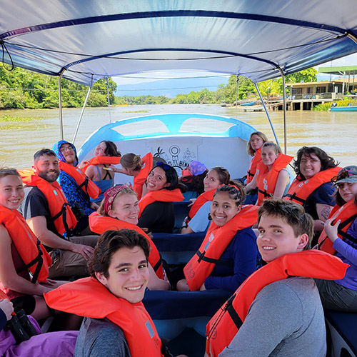
Students Experience Wonders of Costa Rica Through Study Abroad Trip
The Costa Rica Rainforest Experience study abroad trip allowed students to experience the wonders...

Of mice, birds and men: Purdue researcher builds a simulation of how wild birds and rodents affect the spread of avian flu on farms
Trask is writing a new narrative about rats, birds and people as he pursues his doctorate in...

FNR Celebrates Awards, Honors from Spring, Summer 2026
Several Forestry and Natural Resources students, staff and recent alumni have been recognized for...